

Labor Day theatrics - Romeo and Juliette, the star-cross’d lovers.
Updated: Sep 7
Summer forest fires put the best laid plans for a VIME Labor Day event beyond possibility, but I took the opportunity to do some north island exploring with my friend Stuart, who had a new DRZ400 to get to know.
While the whole of the north island isn’t ablaze, the fires that began burning at the start of August after a day of dry lightning, continue to burn in close proximity to the two routes that had been carefully planned and plotted with the collaboration of Gary Neal, Howard Adam and Sol Hutson.
The early decision to scrub the event was influenced by a similar situation that overtook an event that I was close to a few years ago when smoke from a forests fire forced the abandonment of the event on the morning the event was due to take place. A great deal of money had been spent by the event organisers in setting the event up and probably as much again spent by participants traveling to the event and staying in accommodations. Force Majeure circumstances applied and everyone lost their monies, many people were unhappy.
Not wishing to find myself in that situation, the plug was pulled.
So, onto the next thing!
Over the course of the past five years, it has become apparent to me that there is a great deal more to this “motorcycling in the backcountry” thing than simply having a Dualsport or Adveture bike and a Class6 licence. Navigation expertise, local knowledge, route planning, situation-awareness and anticipation. It was called “Mountain Leadership” in the activity groups I was part of in my youth.
For new owners of DS and Adv bikes who are not already familiar with “mountain activities”, these knowledge gaps present major obstacles to getting out there.
I shall attempt to address this “competency gap” through future VIME activities. This blog post is a first chapter in this developing enterprise.
Route descriptions and difficulty ratings.
We all need to be grateful for the difficulty ratings system that has been developed by DSBC in conjunction with the 4WD community, who have come up with a 1 to 6 rating scheme for technical difficulty, where 1 represents easy FSR Mains with no technical challenges and 2 represents the same with surface difficulties such as potholes, rough surfaces, off-camber and sand/mud/standing water.
DSBC 1+2 are at the easier end of the technical difficulty range and require no differentiation between DS and Adv bikes.
DSBC 3 rating introduces steep gradients into equation, presenting a dualsport DS3 difficulty and a Adv3+ or possibly a Adv4 for the largest Adventure bikes.
DSBC 4 rating is more technically challenging still with steepness, looseness, direction changes and sustained climbs and ascents. Dualsport DS4 and Adv4+ to differentiate between the two classes of cross-country bikes.
DSBC 5 +6 are harder and yet harder still and are probably terrains that casual for-fun riders don’t want to venture.
VIME routes will be in the DS 1 - 4 range.
Where me and Stuie went this past weekend.
… but who IS or WAS Victor Ruiz?????

Expect this route to be closed by the first snows of autumn at the highest levels as soon as the start of November and remain closed until the end of May.
As a gift at this summer’s close, I share this route with you by Gaia. I will also write a route description with difficulty ratings of the significant sections according to the scheme I have set out above.
The route start at finish at the Sayward Junction Fisherboy campsite, with conveniently co-located petrol station and pub/restaurant…
Romeo and Juliette, the star-cross’d lovers…
I can’t share the GPX file here, I find.
You will need to open this hyperlink to see the map route.
Follow A Branch Main to the new FSR that follows the White River Gorge south.
Keep left at 50.28575, -125.93655 (leave that mountain trail for the return as it is a 4/4+)
Broadly then it runs past Santa Maria lake and follows A Branch Main (DSBC 1+2) south to UA199 (2+3).
Side quest to go and have a look in Big Elk cave. Apparently this cave is appropriate for a little spelunking adventure (with appropriate equipment, preparation and precautions). We had none of this so when our venture into the cave reached darkness, we returned to the bikes…
Upper Adam Main south (1+2) to CC100 to Kim Creek Main.
CC100 and KCM are where things begin to get more challenging. DS3/Adv3+ is the level - between what had gone before and what was to come afterwards…
But who is or was Victor Ruiz….?
KCM meets Kim800 at the foot of the (in?)famous “Rooney Main descent” and in this version of events is a climb. Without a doubt, this is much more of a challenge as a climb than it is as a descent. DS4/Adv4+ with a couple of crux sections of steep-loose- fist sized pebble sections that rob traction and forward momentum. Stop on this and you are banjaxxed!
To bypass the difficult climb up Kim800, instead of turning left onto Kim800, continue on Kim Creek Main until you meet Highway 19, then turn left and continue until you get to the start of S Main, details below…
The descent down Rooney Lake Main is a 2 with a pleasant side quest up Owen Lake Main (where we came across the entrails of an Elk. Apparently the Elk hunting season hasn’t yet opened, so we presumed the animal had been poached…)

Turn round at the head of the valley between mounts Romeo and Juliette (so much more poetic than “Big Baldy” mountain near Gold River…) and
Join Hwy19 for 3.5km to the start of S Main.
S Main, Kunnum Main to the start of Kunnum East Main. 1 and 2. Watch for forestry industry vehicles.
Kunnum East Main begins to get steep. DS3 Adv3+ steep. Fine views of Mount Eden and glimpses of Romeo.
At 50.24430, -126.21890 you have the option of following the zigzags up the cleared mountainside to excellent viewpoints at 1300m. As far as i know, this is the highest level it is possible to take a motorcycle to on the island. IF YOU KNOW BETTER, PLEASE TELL ME. For steepness, exposure (the drops off the side are eye-opening - look where you want to go, not at what you want to avoid), the drainage gullies dug across the roads, the steep/loose/exposed tight corners, this has to be a 4/4+ difficulty. With confidence, competence and the right tyres the views from the top are worth the effort…
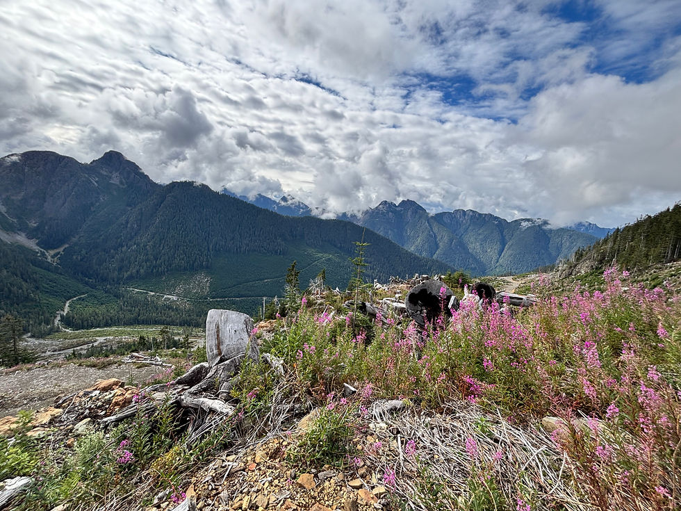
The descent from 1300m to the start of Compton Creek Main demands as much care and attention as the climb. Every way is down and there are no soft landings…
Compton Creek Main to Upper Adam Main is a 3 and after the foregoing, the only thing on you mind needs to be to keep your speed down…
Upper Adam Main to A Branch or Tlowils Lake Main (as you wish) back to Santa Maria Lake is a 1 or a 2, again the pressing hazard is the possibility of oncoming traffic.
The final challenge of the day, if indeed you need one, is to take the mountain road left at 50.28100, -125.94711. This trail, as it is difficult to describe it as a road (although it is indeed a highway as it is a marked FSR on Crown Land) is as tricky and technical as any other section of this route. As a descent as it is in this direction, it is a 3/3+. In the opposite direction it is a 4/4+.
This unnamed road rejoins your outward journey at 50.28615, -125.93638. From there is is very straightforward to return to petrol, food, beer and camp.
The total we covered was around 140km, taking around seven hours with stops for exploration, lunch, examination of a murder scene, looking at lakes and caves and what-have-you.
Stuart was very happy with his new bike, I was very happy with my old bike. The weather was fine and all was well with the day.
There was a follow-up route the following day…. Which will be described in a similar manner as this route description later. I plan to write up a number of routes with descriptions which will be available for purchase as a read-only PDF that you will be able to save to your smartphone or iPad for use as a guidebook. More details later.
Jdb 7 sept 2026

Comments