
The VIME big book of everything. Time Speed Distance rally for motorcycles.
- Jonathan Binnington
- May 3
- 91 min read
The case for motorcycle Time Speed Distance (TSD) Regularity Rallysport to be recognised as a legitimate, competitive road legal motorcycle motorsport genre in British Columbia.

“Road-legal” is the crux of motorcycle TSD rally.
Both the bikes and the riders MUST be legal road users for this motorsport format to work - leveraging the privilege of private motoring over public roads with commercial motoring insurance, while exploiting the power of GPS and smartphone information technology bringing motorcycle motorsport full-circle, back into the realm of non-specialist motorcycle enthusiasts.
In order to make VIME TSD events accessible to the widest audience possible, ie riders who otherwise would have immediately dismissed invitations to participate in events due to high tech-equipment purchase costs - the decision was made to build these events around smartphones, specifically older generation/no SIM card secondhand phones.
The invitation is also for motorcycle motorsport governing bodies is to embrace this fresh activity and attract a new membership to their ranks.
LAND ACKNOWLEDGEMENT
Acknowledgement: I, Jonathan Binnington, as proprietor of Vancouver Island Motosports Events and author of this document, formally and respectfully acknowledge the fact that the lands through which my events pass, the oceans, mountains, rivers and lakes form part of the traditional unceded and never surrendered territories of Canadian First Nations.
I am grateful for our opportunity to travel these roads.
The First Nations are the Mowachaht/Muchalaht Nations in the place now called Gold River, the Uchucklesaht, Hupacasath and Tseshaht First Nations in the place now called Port Alberni, the K’omoks, WeWaiKai and WeiWaiKum First Nations in the place now called Sayward and the Namgis First Nation of the Nimpkish and Kokish watersheds.
Together, these First Nations form part of the Coast Salish First Nations of the Pacific Northwest surrounding Puget Sound and the Salish Sea.
On behalf of all motorcycle riders who travel these roads, I thank you.
CONTENTS
Part 1. Establishing the legitimacy of motorcycle Time Speed Distance rally as a motorcycle motorsport.
Declaration of Interests
Summary
Introduction
TSD Rally - The early years
TSD Rally in the United Kingdom and the USA
Motorcycle TSD development in BC
Paradigm shift
The VIME format
Supporting Legislation, Regulations and Policies
Appendices
Part 2 - Putting it into practice.
XxxxxxxxxxxxxxxxxxxxxxX
1.1 Declaration of Interests.
Jonathan Binnington, author of this work is the Sole Proprietor of Vancouver Island Motosports Events - VIME, a for-profit, sole proprietorship small business registered as such in the Canadian Province of British Columbia.
Vancouver Island Motosports Events - VIME is the business entity through which Jonathan Binnington promotes and produces motorcycle Time Speed Distance (Regularity) Rallies.
The author, Jonathan Binnington asserts his ownership of intellectual property of this work and also asserts that he is the sole author of this text and its appendices.
1.2 SUMMARY.
Time Speed Distance rally, also known as TSD and Regularity rally is a road legal motorsport which has a history stretching back more than a century.
In British Columbia, there are multiple layers of legislation, regulation and policy that explicitly enables TSD motorsport on open public roads - provided the essential requirements of legal private motoring are conformed with.
Motorcycle TSD rally format has been developed in BC by the author of this report and established over the course of five years and ten events. The format draws upon the established principles of TSD and leverages modern GPS technology and smartphones to provide an accessible, entry level motorcycle motorsport for grassroots motorcycle enthusiasts who might otherwise not have the opportunity, finance or option to enter motorsport at a higher level.
Despite the provision of event-specific regulations by promoters/producers of events, this motorsport does not benefit from supervision by a governing body. It is hoped that this situation will be addressed in the future.
1.3 INTRODUCTION.
The purpose of this document is to support the proposition that motorcycle Time Speed Distance (Regularity) Rally be recognised as a legitimate motorsport genre in the Canadian Province of British Columbia. The supporting documentation presented applies specifically to BC and while there may be comparable or duplicate evidence of support in other jurisdictions, no attempt is made to extend justifications to elsewhere. If the reader wishes to investigate the situation in other regions, the author cordially invites motorsport enthusiasts to use this thesis as a basis for their own study of their local legislation.
This document will illustrate the long history of non-race, non-speed competitive motorsport staged on open, public roads in a legal and approved framework. The purpose will be to demonstrate that, provided appropriate conditions are met, it is possible to stage safe, competitive motorsport on open public roads and not impact the amenity and convenience of other road users.
Examples of motorsport events from a variety of countries and jurisdictions will be given to demonstrate this concept to be “tried and tested” elsewhere and ready for adoption into the family of motorcycle motorsports in British Columbia.
1.4 The early years of - the start of the Twentieth Century:
The International Six Day Trial (ISDT).
The original dualsport and adventure bike event?
The International Six Day Trials, precursor and subsequent events.
1903 - 1913. National UK 6 day trials
1913 - 1980. The International Six Days Trials years
1980 - present day. The International Six Days Enduro years
It is said that whatever goes around comes around and there is nothing new under the sun. This potted history will demonstrate how hard it is to be truly original, especially with respect to motorcycles, motorsport and those who wish to measure their competence against their peers.
Information used to compile this article has been sourced from https://speedtracktales.com/index-of-isdt-events/isdt-1913/ Speed Track Tales: A Welsh Perspective on the ISDT

Wikipedia tells that the first motor-cycle was built in 1885 by Gottlieb Daimler and Willhelm Maybach (names which were to become forever part of motoring industry…) and the first series of “production” motorcycles appeared in 1894.
Less than a decade later, 1903, the Auto Cycle Union (ACU) of the United Kingdom was “sanctioning” Six Days Reliability Trials organised by local enthusiasts clubs.
Fast forward a further ten years (1913) and the ACU proposed a national-level reliability trial in the Lake District of Cumberland (much more recently, Cumbria) in partnership with two local motoring clubs. Not wanting to be outdone in difficulty by previous organising groups (for example events in Somerset up Porlock Hill), the Lake District clubs set fearsome routes over five days of riding and nearly 800 miles (1250km) - on bikes barely more powerful than modern-day mopeds with rudimentary (or no) suspension and terrible tyres!

And this representation on Gaia: https://www.gaiagps.com/public/MmMHWw3VqozZucJ0iT3Z6cte

The first ACU International Touring Trial came to the attention of Le Federation Internationale de Club Motocycliste (FIM), the event became the International Six Days Trial (ISDT) and attracted “factory” riders and teams as well as enthusiast privateers. Manufacturers were keen to demonstrate (and develop) the reliability of their products, riders were keen to test their skills.
The “trials” included tests of navigation (no GPS remember - just maps), speed trials, “flexibility” trials (set the machine in top gear and disconnect the clutch release mechanism), timekeeping trials (comparable to Regularity in the modern sense), the need for repairs and spares and finally appearance and final examinations for defective machines.
Yes, there were protests - about the difficulty of the courses, the scoring methods and applications. All the usual…
The venues for the next 55 events (over the subsequent 67 years with gaps for wars) moved around Europe until, in 1981, recognition was given to the fact that the event was no longer a “test of reliability” but had become a six-day enduro - and the event was renamed the International Six Day Enduro (ISDE).
You might not have much difficulty recognising the ISDT spirit in Vancouver Island Motosports Events Regularity-Raid events staged on the gravel roads of the north of Vancouver Island. What goes around really does come around.

Perhaps, the more things change, the more they stay the same?
Some things have changed, the VIME routes appear to be substantially less muddy than the English, Welsh and Scottish roads, the summer weather in BC appears to be much drier and the reliability of modern motorcycles bears absolutely no comparison to the rickety bikes of 100 years ago.

We have satellite navigation and timing, electronic displays, effective equipment (who would ride in tweeds, collar and tie with a flat cap?) and helmet laws…
But, the spirit lives on. Machine and rider through the scenery, sometimes forwards, occasionally backwards…. Bring it on!
There is much history, such as the ISDE where the French team were disqualified on day 2 for missing checkpoints, didn't ride days 3,4 and 5, were reinstated on appeal at the end of day 5 and were awarded the win of the event at the close of day 6 - only to have their win rescinded on appeal as they hadn’t ridden the whole event… but many stranger things (continue to) happen in motorsport!
1.5 Time Speed Distance (TSD) RALLY
In the years after the Second World War, the affordability and popularity of private motoring brought about a new interest in grassroots motorsports. In addition to circuit racing, amateur car clubs developed Time Speed Distance (Regularity) Rally.
In the United Kingdom, the Road Traffic Act permitted “navigation trials” type competition, with car crews following “tulip diagram” road directions while driving as closely as possible to set, legal speeds over predetermined courses. Progress was monitored by small armies of timekeepers staking out timing checkpoints armed with stopwatches, clipboards while wearing duffel coats and wooly hats. The hardest job was calculating the time penalties incurred by dozens of cars over dozens of timed course “legs”, quickly at the end of a long night of competitive driving.
Increasing professionalism of the (amateur) car crews led to ever greater accuracy of crew’s timings over (Road) rally courses which in turn led to event organisers setting increasingly tough-to-meet (i.e. increasingly fast) target leg times and an arms race that was eventually ended when this form of motorsport was ended by the British government of the day. Herein is a particularly relevant lesson for advocates of this genre of motorsport in the future.
In the United States of America, Time Speed Distance rally was (is) also a popular amateur motorsport, but the direction that it took, under the ægis of the Sports Car Club of America (SCCA) was to introduce increasing degrees of precision in time, distance and speed measurement rather than (as in the UK) increasing speeds over open public roads. In this way, TSD Rally has survived as a viable motorsport for crews of road cars driven over tarmac road courses that are open to non-event traffic.
Currently, depending on the class of competition participation, SCCA TSD rallies are set on courses whose distances are set to precisions of inches per mile, times are measured to decimals of seconds per hour and speeds are measured to corresponding precision.
1.6 Motorcycle TSD rally development in BC utilising highway-designated gravel roads including Forest Service Roads (FSRs).
While developing the BC/motorcycle version of TSD rally, a number of “precision limits” have been highlighted as sources of barriers to riders achieving near-perfect time scores. These unavoidable uncertainties include:
Distance measurement discrepancies between geometric/cartographic methods and real-world GPS and wheel distance measurement.
Inherent speedometer inaccuracies due to a combination of the above and instrumentation shortcomings.
The challenge posed to riders by simultaneously coping with the challenge of riding their machines over less than perfect road surfaces, in challenging terrain, while navigating by roadbook and monitoring their speed.
The consequence of these challenges is that typically, each rider will accrue a minimum of several hundred time penalty points over a course that may consist of twenty or more timed legs over two hundred kilometres of course per day.
There hasn’t been any situation develop where two riders have scored the same over a given course and a tie-breaker has been needed to decide the winner of an event.
Therefore it is not anticipated that a speed situation will develop in BC for gravel road TSD rally similar to that which curtailed TSD Road rally in the UK, nor a high-precision situation similar to TSD car rally in the USA.
1.7 PARADIGM SHIFT
Think about the differences between Time Speed Distance regularity rally in a car, with a two-person crew comprising a driver and a navigator - each with separate and very specific jobs, driving tarmac roads, never far from civilisation and safety, with cell phone signal, where the challenge is to drive at an exact and precise speed, with a driver of the car and a navigator/co-driver monitoring speed and navigation
And
A motorcycle rider, riding an unstable vehicle, over rough terrain, in the wilderness, no phone signal, with fewer navigation clues, alone. The challenge is to ensure your own safety, while exercising a high-skill activity, in a challenging environment, solo, all the while simultaneously looking after your own navigation and trying to best meet the set time targets.
This last point, I have found, causes great confusion for some of those from the car TSD community (who strive to achieve zero time penalties). To explain, car TSD has developed into the precision speed and time activity it is because making a test of speedy driving on public roads is not possible. You wind up with racing on the public roads.

In the backcountry, racing is also not possible - BUT - the combined challenges of difficult terrain (steep/loose/overgrown/washed out) with few(er) navigation clues and the systematic cartographic distance measuring errors coupled with "hidden" timing checkpoints (to confound attempts to "game" the timing systems by lurking short of CPs) make the possibility of meeting the target times slim to impossible. Intentionally.
Hence, large Time Penalty scores will be racked up over the individually timed legs and the winner will be the rider with the fewest TPs. Tie-breakers will definitely not be needed!
And so, the paradigm shift has been completed,
from
car road TSD regularities, with the order of
speed precision,
navigation,
driving challenge
to
bike Dualsport Trials, with the order of
Riding challenge
Navigation
Speed precision
It has taken me a while to get there, but that is the flash of insight. The paradigm shift is complete.
1.8 The VIME motorcycle TSD format.
Much of rural BC has been and is currently being worked for natural resources - timer extraction being the main resource in terms of land area. Extraction of cut timber has required the construction of an extensive network of crushed rock resource roads - Forest Service Roads (FSRs) in the language of legislation and regulation. Due to the geographic distribution of remote centres of habitation, FSRs often form the road network connecting these communities and consequentially, FSRs have been afforded the status of “Public Highway”.
As gazetted highways, these forest roads are open to private motoring provided the usual motoring legislation is complied with. The operators of vehicles must be licenced for the vehicle they are operating, the vehicle must be registered as a road-legal vehicle and must be insured (by the Insurance Corporation of British Columbia - ICBC for BC registered vehicles and operators), the vehicles must be operated in manners that comply with BC motoring legislation such as no speeding/racing/stunting.
These resource roads have been built with the intention of allowing access to forest hinterlands by industrial vehicles. They are usually unsuitable for paved-highway passenger vehicles but they are passable by high ground clearance, 4WD vehicles and cross-country motorcycles.
There is a class of road-legal cross-country motorcycles produced for retail sale that is described as “dual sport, adventure and rally-replica”. These motorcycles comply with road use construction (lights, turn indicators, exhaust and noise emissions limits, ABS braking systems etcetera) and have long-travel suspension, high ground clearance and off-road suitable, type approved tyres.
An array of smartphone and tablet applications leveraging GPS positioning and mapping software to provide position, distance and time data replace human timekeepers stationed around competition courses and handle scoring and totalling of scores, simplifying the conversion of raw timing data into event results quickly following the arrival of the final event finisher.
The specific legal, regulatory and policy documents that permit competitive, non-race/non-speed, Time Speed Distance “navigation trials” are presented below.
The stage is set therefore to combine public highways, passing over challenging terrain, in stunning landscapes, ridden by road legal riders and motorcycles, in a competitive format, bringing an old motorsport in a new format to a new (sometimes older) generation of motorcycle enthusiasts.
1.9 Supporting BC Legislation, Regulations and Policy Documents.
There are a number of separate but related sets of enabling Legislation, Regulation and Policy documents that specifically enable this format of TSD motorsport.
They are:
The British Columbia Motor Vehicle Act.
British Columbia Forest Service Roads Use. Regulations.
The Transportation Act.
The Forest Service Roads Use Regulations.
ICBC Motor vehicle insurance - limitations to use.
Land Access
Regulations governing gatherings on Crown Land.
The BC Government Tourism Sector Action plan.
1.9.1 The BC Motor Vehicle Act.
This act lays out a great many ”must do’s” (most of which do not apply to us), a number of definitions (some of which are relevant) and two very relevant “must not do’s” that we will come to soon.
First, some definitions from the Act:
"adult" means a person who has reached 19 years of age
"highway" includes
(a) every highway within the meaning of the Transportation Act,
(b) every road, street, lane or right of way designed or intended for or used by the general public for the passage of vehicles, and
(c) every private place or passageway to which the public, for the purpose of the parking or servicing of vehicles, has access or is invited,
but does not include an industrial road;
But what is an Industrial Road?
The Transportation Act (https://www.bclaws.gov.bc.ca/civix/document/id/complete/statreg/04044_01#division_d2e4156 ) defines New Highways, Arterial Highways, Controlled Access Highways, Scenic Highways and Forest Service Roads…
"industrial road" means industrial road as defined in the Industrial Roads Act, and includes a forest service road as defined in the Forest Act AND (my capitalisation) land designated as a development road under section 139 (1) of the Petroleum and Natural Gas Act;
Therefore, if a FSR is NOT designated as a development road under section 139(1) Petroleum and Natural Gas Act, it is NOT an Industrial Road.
Back to The Motor Vehicle Act
"motorcycle" means a motor vehicle that runs on 2 or 3 wheels and has a saddle or seat for the driver to sit astride
The Act goes on to say motor vehicles and operators must be old enough, licenced, registered and insured.
Chapter 319, Part 9, Section 250 then goes on to define and prohibit…
"race" means circumstances in which, taking into account the condition of the highway, traffic, visibility and weather, the driver or operator of a motor vehicle is driving or operating the motor vehicle without reasonable consideration for other persons using the highway or in a manner that may cause harm to an individual by doing any of the following:
(a) outdistancing or attempting to outdistance one or more other motor vehicles;
(b) preventing or attempting to prevent one or more other motor vehicles from passing;
(c) driving at excessive speed in order to arrive at or attempt to arrive at a given destination ahead of one or more other motor vehicles;
"stunt" means circumstances in which, taking into account the condition of the highway, traffic, visibility and weather, the driver or operator of a motor vehicle is driving or operating the motor vehicle without reasonable consideration for other persons using the highway or in a manner that is likely to cause harm to an individual or likely to distract, startle or interfere with users of the highway by doing any of the following:
(a) causing any or all of the motor vehicle's tires to lift from the road surface;
(b) causing the motor vehicle to lose traction while turning the motor vehicle;
(c) driving the motor vehicle in a manner to cause the motor vehicle to spin;
(d) driving the motor vehicle in a lane intended for oncoming traffic for longer than necessary to pass another vehicle;
(e) slowing or stopping the motor vehicle in a manner that prevents other motor vehicles from passing or in a manner that blocks or impedes other motor vehicles;
(f) without justification, driving as close as possible to another motor vehicle, a pedestrian, or a fixed object.
(None of these conditions are part of VIME gravel road TSD rallies).
Section 3.1 governs the use of electronic devices while driving. (The electronic devices we use are ”hands-free” and adjusted either by way of remote control buttons or require the vehicle to be “parked” for adjustment.)
The takeaway messages from The Motor Vehicle Act is that legal, private motorists have access to most “highways “ in British Columbia, including established FSRs.
Further, “Race” and “Stunting” are prohibited activities that are defined in ways that DO NOT include participation in TSD rallies.
1.9.2. Forest Service Road Use Regulations [Last amended March 30, 2022 by B.C. Reg. 76/2022]
Provisions of Motor Vehicle Act applicable to forest service roads: https://www.bclaws.gov.bc.ca/civix/document/id/complete/statreg/70_2004
The following provisions of the Motor Vehicle Act apply to all forest service roads as if a forest service road were a highway:
(a) section 1; (b)section 2 (5), (6) and (7); (c) section 24 (1) and (2); (d) section 33 (1) insofar as it applies to a driver's licence or a driver's certificate; (e) section 68; (f) section 70; (g) section 73; (h) section 84; (i) sections 141 and 142; (j) sections 144 and 145; (k) sections 149 and 150; (l) sections 157 to 160; (m) section 162; sections 169 to 172; (o) sections 185 and 186; (p) section 194; (q) sections 206 (1) to (3) and 207; (r) section 221; (s) sections 224 to 229.
Liability insurance
12 (1) A person must not operate or cause to be operated a motor vehicle or trailer, other than a motor vehicle or trailer described by section 2 (5) of the Motor Vehicle Act, on a forest service road unless
(a) the driver, motor vehicle and trailer are insured under a valid and subsisting contract of accident insurance providing insurance against liability to third parties in the amount of at least $200 000, and
(b) the driver carries written evidence, supplied by the insurer, of the insurance referred to in paragraph (a), or a copy of that written evidence, and produces it, on demand, to a peace officer or an official.
So, this Regulation further confirms the public’s ability to use FSRs in the legislation of regulated, private motoring.
And further in support from the BCGovt…
1.9.3 Forest Service Roads.
“Resource roads are constructed to develop, protect and access B.C.'s natural resources. They are used primarily by industrial vehicles engaged in forestry, mining, oil and gas or agriculture operations. In addition to resource industries, resource roads are used by the general public and commercial operators, such as ski hills or fishing lodges. They serve as crucial links for rural communities and access to recreational opportunities.”
1.9.4 ICBC and motor Insurance
ICBC is the only BC provider of “in operation” motor insurance. Insurance is required to be in effect on all roads where motoring is permitted. Includes FSRs but does not include “off road” motoring. Hence VIME sticks to FSRs.
“All Risks”. ICBC insurance, vehicle use in connection with the insured business or profession while operating the insured motorcycle on public roads ie FSRs but not off-road/single track. (Also mentioned above)
Citation:
Division 3 – General Terms and Conditions
3.1 Application – Unless otherwise provided, the terms and conditions of this Division 3 apply to all Divisions of this policy.
3.2 Policy does not apply – Unless otherwise provided, this policy does not apply and no coverage will be provided in respect of
a vehicle licensed under section 9 of the Motor Vehicle Act while the vehicle is being operated off a highway, [Highway is defined above in the Motor Vehicle Act. Off Highway use is not ICBC insured, FSRs ARE Highway]
……. (c)……. (d)…..
(e) a vehicle being used in a contest, show or race, or in advanced or performance driver training, if [IF]
(i) the activity is held or conducted on a track or other location temporarily or permanently closed to all other vehicle traffic, and
(ii) there exists an element of race or speed test, which means driving at high speed, and includes passing manoeuvres, driving in close proximity to another vehicle or assessing vehicle limitations in speed, acceleration, turning or braking,
[(e), (i) and (ii) DO NOT apply to gravel TSD rallies.]
Division 8 – Prescribed Conditions
Prohibited use
The insurer is not liable to an insured who breaches this condition or a sub-condition of this condition.
3 (1)
(2) An insured must not operate a vehicle for which coverage is provided under this contract
(a) if the insured is not authorized and qualified by law to operate the vehicle, (b) for an illicit or prohibited trade or transportation,
(c) to escape or avoid arrest or other similar police action, or
(d) in a race or speed test. [Race and Speed Test defined above].
1.9.5 Land access.
You are probably aware that there is a Forestry company conglomerate called Mosaic. One of the main companies in the conglomerate is TimberWest.
Mosaic own large portions of the forests on the south and central areas of Vancouver Island.
As landowners, they permit controlled recreational access to their forests.
“TimberWest is western Canada’s largest private managed forest landowner with 325,000hectares/800,000 acres on Vancouver Island. The company also owns renewable Crown harvest rights to 700,000 cubic meters of timber per year. TimberWest is owned by two leading Canadian pension funds, British Columbia Investment Management Corporation (bcIMC) and the Public Sector Pension Investment Board (PSP Investments).
Mosaic grants public access to their lands as fits their business operations. If it is gated and closed, keep out! You are trespassing - a Civil wrong, not a criminal wrong. If you wilfully damage anything you are probably committing a criminal act.
The forests on Vancouver Island that are not owned by Mosaic companies are owned by the Province and managed by timber and forestry companies under Tree Farm Licences. This includes the pacific side of central Vancouver Island and pretty much all the north of the island.
One of the main companies is Western Forest Products.
1.9.6. Camping and Recreation
Western Forest Products welcomes you to enjoy the great outdoors camping, hiking, boating and fishing in our sustainably managed working forests.
Most recreational access is provided by our extensive network of active resource roads.
The safest time to travel is weekends or on weekdays after 6 pm and before 5 am.
Always drive as if there is a loaded truck around the next corner.
The speed limit is 50 km/h or less depending on road conditions.
Never enter areas where active harvesting or road construction signage is posted. Active tree falling, yarding and blasting may be going on in these areas.”
While Mosaic go to great effort to control access to their backcountry, WFP are obliged to facilitate responsible access to the Provincial lands that they manage…
Next, there are BC Government regulations that limit the number of individuals that may later on BC Crown Land (forests) for the purpose of recreational or sporting activities.
1.9.7 Regulations governing gatherings on Crown Land.
These are the regulations
“ The Forest and Range Practices Act (FRPA) and the Forest Recreation Regulation (FRR) identify when authorization is required to use a recreation site, recreation trail, interpretive forest site or trail-based recreation area, as well as to construct, maintain, or rehabilitate a trail or other recreation facility.
Recreation Sites and Trails B.C. (RSTBC) is the agency responsible for providing these authorizations.”
A thorough reading of the regulations clearly shows that these regulations apply to Crown forests, recreation sites, recreation trails, interpretive forests and trail-based recreation areas.
Vancouver Island Motosports Events do not encroach upon Recreation Sites, Recreation Trails, Interpretive Forest sites or trail-based recreation areas.
Vancouver Island Motosports Events are confined entirely to public right of way, highway-designated Forest Service Roads on Crown Land. Camping and gatherings occur on private campgrounds and highway-designated parking lots (start/finish areas).
All event participants are licenced, ICBC insured and registered (highway plated) private motorists, operating under the published terms of ICBC insurance and BC motoring law.
I’ve opened a few of the hyperlinks in the primary document, they lead to further documents with this language
“ Authorization for Construction, Maintenance or Rehabilitation of Trails or Recreation Facilities on Crown Land”
Elsewhere there are references to an upper limit of 100 participants in motorised events. I presume this relates to events held on motorised recreation sites such as Whiskey Creek (Vancouver Island) and similar…?
These are not venues used by VI Motosports Events.
So, on closer inspection it seems reasonable to conclude that these regulations do not apply to the motorcycle Regularity Rally events staged over highway-designated Forest Service Roads on Crown Land.
1.9.8 The BC Government Tourism Sector Action plan.
And
These are BC Government Policy documents, expressing a series of desired ambitions and intentions rather than a series of must-and-must-not-do’s. Therefore selected quotations from the document will be use to illustrate the ambition of the government to encourage Leisure & Tourism in the overall future economy of British Columbia.
“Tourism in British Columbia is more than an industry - it’s a cornerstone of community vitality. It fuels small businesses, sustains local jobs, and ensures residents enjoy enriching experiences close to home. …tourism in BC strengthens local economies and creates vibrant communities. Hon Anne Kang, Minister of Tourism, Arts, Culture and Sport.”
“Throughout the next decade, tourism will play a central role in diversifying markets and local economies…”
“We’re committed to supporting our mountain resorts, adventure tourism operators and commercial recreation providers who deliver safe, world-class experiences that connect visitors with BC’s natural landscapes”
1.9.9. Closing remarks.
The purpose of the foregoing has been to demonstrate to all interested parties that motorcycle Time Speed Distance - Regularity rally, conducted according to the operating legislation and regulations is a viable, legal, public highway, competitive motorsport.
Further, the genre-format has matured to the point where recognition and regulation of events by a provincial motorcycle motorsport governing body would be advantageous to both producers/promoters of such events and to the governing body by widening the influence of the governing body.
Finally, the assembled documentary evidence of legality is intended to serve as a “in one place” work of reference should the need to demonstrate the legality of such events to individuals or parties who may have an interest in questions of legality.
1.10. Appendices.
1.10.1 The GoldRiver Rules
1.10.2 VIME Liability Waiver
1.11. A note on BC vehicle lighting regulations, with specific reference to helmet mounted lights.
BC-Canada Motor Vehicle Lighting Regulations. From: B.C. Reg. 26/58
This regulation is reprinted here in full to demonstrate that helmet mounted “rally lights” fall outside the terms of this Regulation.
Division 4 — Lamps
Hours prescribed for lighted lamps
4.01A person who drives or operates a vehicle on a highway must illuminate the lamps required by this Division
(a) from 1/2 hour after sunset to 1/2 hour before sunrise, and
(b) at any other time when, due to insufficient light or unfavourable atmospheric conditions, objects on the highway are not clearly discernible at a distance of 150 m.
[en. B.C. Reg. 476/98, s. 2.]
General lighting requirements
4.02(1) A vehicle on a highway must only be equipped with and use lamps, reflectors or other illuminating devices authorized by this Division or authorized in writing by the director.
(2) A vehicle on a highway must be equipped with lamps equivalent to those provided by the original manufacturer in accordance with the requirements that applied under the Motor Vehicle Safety Act (Canada), or a predecessor to that Act, at the time of vehicle manufacture.
(3) All lamps, lamp bulbs and reflectors required or permitted by this Division must comply with
(a) the approved standards established by the Motor Vehicle Safety Act (Canada) and the applicable SAE standards,
(b) the conditions of use described in this Division, and
(c) the requirements of Table 1 of the Schedule to this Division.
(4) The function of 2 or more lamps or reflectors may be combined if each function meets the following requirements:
(a) no turn signal lamp may be combined optically with a stop lamp unless the stop lamp is extinguished when the turn signal is flashing;
(b) a clearance lamp must not be combined optically with a tail-lamp or identification lamp.
(5) The director may exempt vehicles or classes of vehicles from the requirements of this section.
[en. B.C. Reg. 476/98, s. 2; am. B.C. Reg. 135/2003, s. 1.]
Mounting of lamps and reflectors
4.03(1) If 2 lamps of the same type are required or permitted on a vehicle, the lamps must be mounted at the same height unless otherwise specified in this Division.
(2) If 2 lamps of the same type are required or permitted on the side, front or rear of a vehicle, the lamps must, unless otherwise specified in this Division, be mounted with one lamp at or near the extreme left and one lamp at or near the extreme right of the vehicle, so as to indicate the approximate width of the vehicle.
[en. B.C. Reg. 476/98, s. 2.]
General maintenance
4.04(1) Lighting devices required by this Division must be maintained in good working order.
(2) Lamps and reflectors required by this Division
(a) must be securely mounted on the vehicle,
(b) must not have any cracked, broken, missing or incorrectly installed lenses, and a lamp must not have bent or broken rims that allow water to enter the lamp, and
(c) must not be shielded, covered or obscured by any part of the vehicle or load or by dirt or other material.
[en. B.C. Reg. 476/98, s. 2.]
Headlamps
4.05(1) A motor vehicle must be equipped with either one or 2 headlamps mounted on each side of the front of the vehicle and capable of displaying white light.
(2) The headlamps must be mounted at a height of not less than 56 cm and not more than 1.37 m.
(3) Subsection (2) does not apply to highway construction and maintenance equipment.
(4) Despite subsection (1), a motorcycle must be equipped with at least one and not more than 2 headlamps.
(5) A motorcycle manufactured after December 31, 1974 must be equipped with a headlamp or headlamps which automatically turn on when the engine of the motorcycle is started and which remain illuminated as long as the engine is running.
(6) The headlamp on a motorcycle travelling at less than 50 km/h must reveal an object at a distance of 30 m.
(7) The headlamp on a motorcycle travelling at 50 km/h or more must reveal an object at a distance of 60 m.
(8) A motorcycle may be equipped with modulating headlamps if the headlamps comply with section 5.6 of the Technical Standards Document No. 108, Motor Vehicle Safety Regulations (Canada).
[en. B.C. Reg. 476/98, s. 2.]
Multiple beam headlamps
4.06(1) The headlamps of a motor vehicle must function so that the driver may select lamps capable of displaying
(a) an upper beam of light which, regardless of the load on the vehicle, will reveal an object at a distance of 100 m, and
(b) a lower beam of light which, regardless of the load on the vehicle, will reveal an object at a distance of 30 m and the high intensity portion of the lower beam will not strike the eye of an oncoming driver.
(2) The lighting system must include a tell-tale lamp which clearly indicates when the upper beam of light is being displayed.
(3) Subsection (2) does not apply to a motor vehicle manufactured before January 1, 1940.
(4) If an automatic dimmer switch is installed, the device must have a manual control.
(5) A person who drives or operates a motor vehicle must not illuminate the upper beam of a headlamp if another motor vehicle is within a distance of 150 m from that vehicle, unless the driver has overtaken and passed the other vehicle, so that the high intensity portion of the beam does not strike or reflect into the eye of the other driver.
(6) Whenever a motor vehicle is parked or standing on a highway, the upper beam of the motor vehicle headlamps must not be illuminated.
[en. B.C. Reg. 476/98, s. 2.]
Single beam headlamps
4.07Despite section 4.06, a motor vehicle, including a motorcycle, may be equipped with single beam headlamps instead of multiple beam headlamps if
(a) the illuminated headlamps reveal an object at a distance of 60 m, and
(b) each headlamp is mounted and directed so that the high intensity portion of the beam is, at a distance of 8 m from the headlamp, at least 12 cm below the height of the headlamp and, at a distance of 25 m from the lamp, not higher than 1.06 m from the road surface.
[en. B.C. Reg. 476/98, s. 2.]
Daytime running lamps
4.08A motor vehicle may be equipped with daytime running lamps, mounted on the front of the vehicle at a height of not less than 30 cm and not more than 2.11 m, that comply with the requirements of the Motor Vehicle Safety Act (Canada).
[en. B.C. Reg. 476/98, s. 2.]
Auxiliary driving lamps
4.09(1) A motor vehicle may be equipped with 2 auxiliary driving lamps, mounted on the front of the vehicle at a height of not less than 40 cm and not more than 1.06 m, that are capable of displaying only white light.
(2) An auxiliary driving lamp must be directed so that the high intensity portion of the beam is, at a distance of 8 m from the lamp, at least 12 cm below the height of the lamp and, at a distance of 25 m from the lamp, not higher than 1.06 m from the road surface.
(3) An auxiliary driving lamp must operate so that it is illuminated only when the upper beam of a multiple beam headlamp is illuminated.
[en. B.C. Reg. 476/98, s. 2.]
Parking lamps
4.10(1) A vehicle may be equipped with 2 parking lamps, mounted on the front of the vehicle, that are capable of displaying only white or amber light.
(2) A vehicle may be equipped with 2 parking lamps, mounted on the rear of the vehicle, that are capable of displaying only red light.
[en. B.C. Reg. 476/98, s. 2.]
Fog lamps
4.11(1) A motor vehicle may be equipped with 2 fog lamps, mounted on the front of the vehicle below the headlamps, that are capable of displaying only white or amber light.
(2) Each fog lamp must be
(a) mounted not more than 30 cm below the headlamps, and
(b) adjusted and aimed so that, at a distance of 8 m from the lamp, the centre of the beam is at least 10 cm below the height of the fog lamp.
(3) The fog lamp wiring and switch must permit simultaneous operation of the parking lamps, tail lamps, licence plate lamp and, if required, clearance lamps.
(4) The operator of a vehicle may use fog lamps instead of headlamps when atmospheric conditions make the use of headlamps disadvantageous.
[en. B.C. Reg. 476/98, s. 2.]
Side-marker lamps
4.12(1) A vehicle may be equipped with
(a) 2 side-marker lamps, mounted on each side of the vehicle near the front, that are capable of displaying only white or amber light, and
(b) 2 side-marker lamps, mounted on each side of the vehicle near the rear, that are capable of displaying only amber or red light.
(2) The side-marker lamps referred to in subsection (1) may operate in conjunction with turn signal lamps or the hazard warning signal.
(3) A vehicle with an overall width of 2.05 m or more, or having a gross weight in excess of 1 400 kg, may be equipped with side-marker lamps mounted on each side of the vehicle at the horizontal mid-point of the vehicle.
[en. B.C. Reg. 476/98, s. 2.]
Turn signal devices
4.13(1) A vehicle may be equipped and mounted with
(a) a lamp type turn signal system, or
(b) a semaphore turn signal device,
functionally equivalent to original equipment supplied by the vehicle manufacturer or of a type or make approved by the director.
(2) A lamp type turn signal system must
(a) have 2 lamps, mounted on the front of the vehicle, that are capable of displaying flashes of white or amber light which are visible to the front,
(b) have 2 lamps, mounted on the rear of the vehicle, that are capable of displaying flashes of red or amber light which are visible to the rear,
(c) be visible on each side of the vehicle at a distance of 100 m in normal sunlight at an angle of 45° from the longitudinal axis of the vehicle, and
(d) include a tell-tale lamp which gives a clear indication that the system is activated.
(3) During the time specified in section 4.01, a semaphore turn signal device must be capable of illumination by light or reflection visible from a distance of 100 m.
(4) A public passenger vehicle or a commercial vehicle that weighs more than 4 500 kg may be equipped with supplementary turn signal lamps in addition to the turn signal system required by subsection (2).
(5) A turn signal lamp must be mounted on the vehicle at a height of not less than 38 cm and not more than 1.83 m.
(6) Subsection (5) does not apply to highway construction vehicles, maintenance vehicles, tow cars or vehicles being towed by a tow car.
(7) A vehicle which is being transported in a drive-away/tow-away operation, or is being towed by a tow car, must have turn signals that are synchronised with the turn signals of the towing vehicle when the tow vehicle turn signals are illuminated.
(8) Despite subsection (5), a tow car may be equipped with supplementary turn signal lamps mounted within the maximum allowable vehicle height (4.15 m) and as far forward as the rear of the cab.
(9) The centre of the front signal lamps must be at least 10 cm from the edge of the low beam headlamps
[en. B.C. Reg. 476/98, s. 2; am. B.C. Reg. 135/2003, s.1.]
Cowl and fender lamps
4.14A vehicle may be equipped with no more than 2 cowl or fender lamps, mounted on each front cowl or front fender of the vehicle, that are capable of displaying only amber or white light visible to the front and amber or red light visible to the rear.
[en. B.C. Reg. 476/98, s. 2.]
Tail lamps
4.15(1) A motor vehicle, trailer or semitrailer must be equipped with 2 tail lamps, mounted on the rear of the motor vehicle, trailer or semitrailer, that are capable of displaying only red light visible from a distance of 150 m to the rear on both sides of the motor vehicle, trailer or semitrailer at an angle of 45° from the longitudinal axis of the motor vehicle, trailer or semitrailer.
(2) Despite subsection (1),
(a) a motorcycle may be equipped with only one tail lamp, and
(b) a vehicle manufactured before January 1, 1959 may be equipped with only one tail lamp.
(3) Each tail lamp must be mounted on the vehicle at a height of not less than 38 cm and not more than 1.83 m.
(4) Subsection (3) does not apply to vehicles being towed by a tow car.
(5) Despite subsection (3), a tow car may be equipped with 2 supplemental tail lamps mounted within the maximum allowable vehicle height (4.15 m) and as far forward as the rear of the cab.
(6) A vehicle which is being transported in a drive-away/tow-away operation, or is being towed by a tow car, must have 2 tail lamps that are synchronised with the tail lamps of the towing vehicle when the tow vehicle tail lamps are illuminated.
[en. B.C. Reg. 476/98, s. 2.]
Licence plate lamp
4.16(1) The rear licence plate of a vehicle must be illuminated by a lamp that is capable of displaying only white light so that the numbers on the licence plate are legible from a distance of 15 m to the rear of the vehicle.
(2) The lamp required by subsection (1)
(a) must illuminate whenever the headlamps or parking lamps are illuminated, and
(b) must not project white light to the rear of the vehicle.
[en. B.C. Reg. 476/98, s. 2.]
Stop lamps
4.17(1) A motor vehicle, trailer or semitrailer on a highway must be equipped with 2 stop lamps, mounted on the rear of the motor vehicle, trailer or semitrailer, that are visible to the rear on both sides of the motor vehicle, trailer or semitrailer at an angle of 45° from the longitudinal axis of the motor vehicle, trailer or semitrailer.
(2) Despite subsection (1),
(a) a motorcycle may be equipped with only one stop lamp, and
(b) a vehicle manufactured before January 1, 1959 may be equipped with only one stop lamp.
(3) A stop lamp must be
(a) capable of displaying only red light visible from a distance of 100 m to the rear of the vehicle in normal sunlight,
(b) illuminated exclusively upon application of the service brake, and
(c) mounted on the vehicle at a height not less than 38 cm and not more than 1.83 m.
(4) Subsection (3) (c) does not apply to vehicles being towed by a tow car.
(5) A vehicle may be equipped with one additional centre-mounted stop lamp that is capable of displaying only red light visible to the rear.
(6) A public passenger vehicle may be equipped with 2 supplemental rear stop lamps.
(7) A tow car may be equipped with 2 supplemental rear stop lamps mounted within the maximum allowable vehicle height (4.15 m) and as far forward as the rear of the cab.
(8) A vehicle which is being transported in a drive-away/tow-away operation, or is being towed by a tow car, must be equipped with and illuminate 2 stop lamps that are synchronized with the stop lamps of the towing vehicle when the tow vehicle stop lamps are illuminated.
[en. B.C. Reg. 476/98, s. 2.]
Backup lamps
4.18(1) A vehicle may be equipped with not more than 2 backup lamps, mounted on the rear of the vehicle, that are capable of displaying only white light to the rear of the vehicle.
(2) A backup lamp must illuminate only when the vehicle is in reverse gear.
[en. B.C. Reg. 476/98, s. 2.]
Docking lamps
4.19(1) A truck or truck tractor, and no other vehicle, may be equipped with 2 docking lamps, directed to the rear of the vehicle, which illuminate only when the truck or truck tractor is in neutral or reverse gear.
(2) The docking lamps must be directed in such a way that the high intensity portion of the beam does not strike the eye of another driver. [en. B.C. Reg. 476/98, s. 2.]
Lamps or flags on front and rear projections
4.20(1) A vehicle on a highway must not carry a load or have an integral part of the vehicle which projects more than 1 m beyond the front wheels or the front bumper of the vehicle unless,
(a) during the time specified in section 4.01, the extreme tip of the projection is illuminated with a lamp that is capable of displaying only white light visible from the front and sides of the vehicle, and
(b) at any time other than that specified in section 4.01, a red flag or cloth that complies with section 8.05 (c) of the Commercial Transport Regulations and which is visible from the front and sides of the vehicle is attached to the extreme tip of the projection.
(2) A vehicle on a highway must not carry a load or have an integral part of the vehicle which projects more than 1.2 m to the rear of the load-deck or body of the vehicle unless,
(a) during the time specified in section 4.01, the extreme tip of the projection is lighted with a lamp that is capable of displaying only red light visible from a distance of 150 m to the rear of the vehicle, and
(b) at any time other than that specified in section 4.01, a red flag or cloth that complies with section 8.05 (c) of the Commercial Transport Regulations and which is visible to the driver of a vehicle to the rear is attached to the extreme tip of the projection.
[en. B.C. Reg. 476/98, s. 2.]
Reflective devices
4.21(1) A vehicle must be equipped with at least one red reflector at the rear of the vehicle, either separate or incorporated into a tail lamp, that is mounted at a height of not less than 38 cm and not more than 1.83 m.
(2) Subsection (1) does not apply to a vehicle manufactured before January 1, 1958.
(3) Only amber reflectors may be mounted on the front or side of a vehicle.
(4) Only red reflectors may be mounted on the rear of a vehicle or on the side of the vehicle at or toward the rear of the vehicle.
(5) A vehicle with an overall width of 2.05 m or more, or a trailer or semitrailer having a gross weight in excess of 1 400 kg, must be equipped with at least
(a) 2 amber reflectors mounted on the side of the vehicle, trailer or semitrailer near the front,
(b) 2 amber reflectors mounted on the side of the vehicle, trailer or semitrailer near the rear, and
(c) 2 red reflectors mounted on the rear of the vehicle, trailer or semitrailer.
(6) A trailer or semitrailer must be equipped with at least one red reflector on the rear of the vehicle at each side.
(7) A pole trailer must be equipped with at least
(a) one amber reflector on each side of the vehicle at the front and the horizontal mid-point, and
(b) one red reflector on the rear of the vehicle or load at each side.
(8) A commercial trailer with a width of more than 2.05 m and a gross vehicle weight rating of more than 4 536 kg must be equipped with reflective markings on the rear and side of the vehicle to meet the approved standards established by the Motor Vehicle Safety Act (Canada) and the applicable SAE standards
(a) on and after January 1, 2000 if the vehicle was manufactured on or after December 1, 1993, and
(b) on and after January 1, 2002 if the vehicle was manufactured before December 1, 1993.
(9) Despite subsections (1) to (7), reflective markings may replace red or amber reflectors on the side or rear of a vehicle.
[en. B.C. Reg. 476/98, s. 2; am. B.C. Reg. 413/99.]
Clearance lamps
4.22(1) A commercial vehicle may be equipped with 2 amber clearance lamps mounted on the front of the vehicle, near or at the top of the vehicle, in such a manner as to indicate the overall width of the vehicle.
(2) A truck tractor must be equipped with amber clearance lamps mounted on the front of the vehicle.
(3) During the time specified in section 4.01, a vehicle with an overall width of 2.05 m or more, or a trailer or semitrailer having a gross weight in excess of 1 400 kg, must illuminate
(a) a clearance lamp,
(i) mounted on the front at each side of the vehicle, that is capable of displaying only amber light visible from a distance of 150 m to the front, or
(ii) mounted on the front of the vehicle, that is capable of displaying amber, green or white light, but only if the vehicle was manufactured before January 1, 1959, and
(b) a clearance lamp, mounted on the rear at each side of the vehicle, that is capable of displaying only red light visible from a distance of 150 m to the rear.
(4) Subsection (3) does not apply to a pole trailer.
(5) Clearance lamps on vehicles manufactured after December 31, 1993 must be mounted near or at the top of the vehicle in such a manner as to indicate the overall width of the vehicle. [en. B.C. Reg. 476/98, s. 2.]
Identification lamps
4.23(1) A commercial vehicle may be equipped with 3 identification lamps, mounted in a row on the front of the vehicle at or near the top, that are capable of displaying only amber light.
(2) A commercial vehicle with an overall width of 2.05 m or more may be equipped with 3 identification lamps,
(a) mounted in a row on the rear of the vehicle at or near the top, or
(b) mounted below the rear door of a van trailer when the top header is 2.5 cm or less in width,
that are capable of displaying only red light.
[en. B.C. Reg. 476/98, s. 2.]
Spotlamps
4.24(1) A motor vehicle on a highway may be equipped with not more than 2 spotlamps that are capable of displaying only white light.
(2) An illuminated spotlamp must be directed so that the high intensity portion of the beam will not strike the windows, mirrors or occupants of another vehicle.
(3) A spotlamp must be securely fastened to the motor vehicle, and the lamp or control must not interfere with the driver's vision or control of the vehicle.
(4) A spotlamp must not be used in substitution of headlamps.
(5) Subsections (1) to (3) do not apply to emergency vehicles.
[en. B.C. Reg. 476/98, s. 2.]
Off-road lamps
4.25Despite section 4.04 (2) (c), a vehicle equipped with off-road lamps when on a highway must have the off-road lamps concealed with opaque covers.
[en. B.C. Reg. 476/98, s. 2.]
Sequential lamps
4.26A sequential direction lamp may only be used by emergency vehicles and public and private utility highway maintenance vehicles.
[en. B.C. Reg. 476/98, s. 2.]
Lighted signs and air deflectors
4.27(1) A motor vehicle must not be equipped with an illuminated taxi sign except in accordance with conditions set out in writing by the director.
(2) A motor vehicle, other than a motorcycle or taxi, may be equipped with one internally illuminated sign if the sign complies with all of the following:
(a) the sign is securely mounted on the roof of the vehicle, has no moving parts and does not overhang the roof of the vehicle;
(b) the sign does not increase the overall height of the vehicle by more than 50 cm, and the vehicle and sign together do not exceed 4.15 m in overall height;
(c) the surfaces of the sign are illuminated only to the sides of the vehicle and not to the front or rear;
(d) the illuminated surface of the sign is not more than 3 000 cm2 on each side;
(e) the illuminated surfaces of the sign do not depict graphics which resemble any official traffic control device;
(f) the light displayed is uniformly diffused and is a non-flashing light of not more than 32 watts.
(3) Despite subsection (2) (c) and (d), a truck or truck tractor may be equipped with an internally illuminated air deflector mounted on the roof of the truck or truck tractor if
(a) the illuminated surface of the deflector does not exceed 4 700 cm2 in area and is no closer to the road surface than 1.5 m at any point, and
(b) the deflector does not reduce the field of vision of the driver of the vehicle or obscure the clearance or identification lamps.
(4) A public passenger vehicle may be equipped with one or more signs having letters not more than 20 cm in height and illuminated by diffused white light.
(5) For the purposes of section 19.15 (1) (a), a bus may be equipped with not more than one illuminated yield sign if the yield sign
(a) displays, in amber flashes of light, the word "YIELD" so that the word, when illuminated, is visible from a distance of 100 m in normal sunlight,
(b) is mounted to the left side at the rear of the bus,
(c) has an automatic cancellation feature on a timer with a maximum duration of 10 seconds, and
(d) is connected to a tell-tale lamp or device that gives a clear indication to the driver of the bus that the yield sign is in operation.
[en. B.C. Reg. 476/98, s. 2; am. B.C. Regs. 91/99, s. 1 (a); 135/2003, s. 1; 351/2008, Sch. s. 5.]
Flashing lamps
4.28(1) A vehicle on a highway may only be equipped with lamps that are capable of displaying flashes of light if
(a) the lamps are operated in accordance with this Division, or
(b) the director has given written permission and the lamps are lighted in accordance with the conditions specified by the director.
(2) Red, white or amber flashing lamps may be used on the following vehicles:
(a) a fire department vehicle driven by a member of the fire department in the discharge of the member's duties;
(b) an official vehicle driven by a peace officer, constable or member of the police branch of Her Majesty's Armed Forces in the discharge of the officer's duties;
(c) an ambulance, as defined in the Emergency Health Services Act, if the ambulance is responding to an emergency call or transporting a patient and it is essential for the ambulance to gain the right of way;
(d) a bus described in section 169.1 (4) (a) or (b) of the Act if the flashes of light are emitted
(i) from the centre and right side clearance lights at the rear of the bus, and
(ii) only when the bus is stopped, standing or parked at a bus stop.
(3) Only those vehicles described in subsection (2) may be equipped with a system which alternately flashes the headlamps of the vehicle.
(4) A school bus may be equipped with alternately flashing red lamps and alternately flashing amber lamps of a type approved by the director.
(5) Two amber flashing lamps may be illuminated on the following vehicles:
(a) a tow car while attending a vehicle being connected to or disconnected from the tow car, if the lamps are mounted within the maximum allowable vehicle height of 4.15 m and as far forward as the rear of the cab;
(b) a tow car when towing a vehicle which projects beyond the width of the lane in which it is being towed;
(c) snow removal equipment, sand spreading equipment or other highway maintenance equipment being used on a highway during highway maintenance or construction;
(d) the roof of a pilot car as specified in Division 8 of the Commercial Transport Regulations and illuminated only while escorting an oversize vehicle or load.
(6) A vehicle that under the Commercial Transport Act is an oversize vehicle or is a vehicle used to transport oversized loads may be equipped with and operate flashing amber lamps in accordance with a permit issued under the Commercial Transport Act.
(7) Turn signals, or side-marker lamps used in conjunction with turn signals, may be used as warning lights by a slow moving vehicle as described in Division 7B or as warning lights whenever a vehicle is disabled on a highway.
(8) Any of the following officers may drive an official vehicle equipped with blue flashing lights and illuminate them in the discharge of the officer's duties:
(a) a member of a municipal police force;
(b) a member of the Royal Canadian Mounted Police;
(c) a member of the police branch of Her Majesty's Armed Forces;
(d) a member of the Conservation Officer Service as described in section 106 of the Environmental Management Act;
(e) a person authorised to exercise the powers and duties of a constable or peace officer for purposes set out in section 1 of the Inspectors Authorization Regulation, B.C. Reg. 372/92;
(f) a park ranger appointed under section 4 (2) of the Park Act;
(g) a person employed in the Ministry of Forests and Range who is appointed as a special constable under section 9 of the Police Act;
(h) an employee of the Canada Border Services Agency who is described in paragraph (d) or (d.1) of the definition of "peace officer" in section 2 of the Criminal Code (Canada).
[en. B.C. Reg. 476/98, s. 2; am. B.C. Regs. 91/99, s. 1 (b); 135/2003, ss. 1 and 3; 90/2008; 90/2012; 145/2013, App. 2, s. 11 (a).]
Implements of husbandry (I’ll leave this in for completeness)
4.29(1) An implement of husbandry operating on a highway is exempt from sections 4.02 (3) and 4.03 to 4.27.
(2) During the times specified in section 4.01, an implement of husbandry on a highway must comply with all of the following:
(a) the operator must illuminate 2 lamps that are capable of displaying only amber light, which indicate the extreme left and right of the vehicle, visible from a distance of 100 m to the front;
(b) the operator must illuminate 2 lamps that are capable of displaying only red or amber light, which indicate the extreme left and right of the vehicle, visible from a distance of 100 m to the rear;
(c) on a self-propelled implement, the operator must illuminate one lamp that is capable of displaying only white light, visible from a distance of 150 m to the front, which does not exceed the limitations specified in section 4.05;
(d) if the vehicle extends more than 10 m behind the hitch point, the vehicle must be equipped with amber reflectors visible to the left and the right sides of the vehicle, spaced at 5 m intervals.
[en. B.C. Reg. 476/98, s. 2.]
Slow-moving vehicles
4.30The operator of a slow-moving vehicle on a highway, as described in Division 7B of these regulations, must at all times illuminate amber non-rotating flashing lamps as warning lights visible from a distance of 100 m to the front, and red or amber non-rotating flashing lamps visible from a distance of 100 m to the rear.
[en. B.C. Reg. 476/98, s. 2.]
Schedule
Table 1 – Standards for Approval of a Motor Vehicle Headlamp and Other Illuminating Lamps Aiming Requirements
[en. B.C. Reg. 476/98, s. 2.]
Visual aim based in millimetres at 7.62 metres
HeadlampsBeams to be Used When Aimed or InspectedArea of High Intensity Zone to be Aimed or InspectedLateral AimLateral Inspection ToleranceVertical AimVertical Inspection Tolerance146 mm Type 1 sealed beamUpperCentreAt V150 mm left to
150 mm right of V13 mm up from H125 mm up to
100 mm down
from H146 mm and 178 mm Type 2 sealed beam Lower Left Edge
Top Edge 25 mm right of V100 mm left to
150 mm right of V60 mm up from H175 mm up to
50 mm down from H178 mm sealed beam not marked Type 2UpperCentreAt V150 mm left to
150 mm right of V13 mm up from H125 mm up to
100 mm down
from European headlamps marked "E" and beam lamps marked "R" or "HR"UpperCentreAt V125 mm left to
125 mm right of VAt HAt H to 115 mm belowLow beam lamps marked "C" or "HC"LowerJunction of horizontal and sloped cut off
Top edge of horizontal cut offAt V125 mm left to
125 mm right of V
100 mm below H75 mm below to
190 mm below Dual beam lamps marked "CR" or
"HCR"Lower and UpperTop edge of horizontal cut off
CentreAt V125 mm left to
125 mm right of V100 mm below H75 mm below to
190 mm below Fog lamps symmetrical Centre
Top edgeAt V150 mm left to
150 mm right of V100 mm below HAt H or below Fog lamps asymmetrical Left edge
Top edge25 mm right of V100 mm left to
100 mm right of V60 mm above V175 mm above to
50 mm below Auxiliary passing lamp Left edge
Top edge25 mm right of V100 mm left to
100 mm right of V60 mm above H175 mm below to
50 mm below Auxiliary driving lamp CentreAt V150 mm left to
150 mm
right of V13 mm up from H125 mm up to 100 mm
down from Motor vehicle minimum beam candela: Upper beam, 10 000; lower beam, 7000.
Motorcycle minimum beam candela: Upper beam, 5 000; lower beam, 3 500.
This standard is based on S.A.E. standard-Lighting Inspection Code and recommended headlamp tolerances for E.C.E. lamps
supplied by the Road and Motor Vehicles Safety Section, Transport Canada.
Abbreviations: V=vertical centreline straight ahead of lamp centre. H=horizontal centreline at level of lamp centre.
Part 2. Putting it into practice…
Having established motorcycle Time Speed Distance / Regularity rally on the gravel road network of British Columbia as a valid motorsport, we will now turn our attention to the practicalities of running and participating in an event.
Contents. Part 2
What Time Speed Distance rally is and is not
Some of the history
The bikes and riders
The tech, the apps and the hardware
Gaming the system
Some of the obscure points of cartography, topography and geometry
Applying it all to a real event
Untoward incidents and how to interact with forest industry traffic
Appendices
2.1. What Time Speed Distance Rally is (and is not)…
This is the “new readers join here moment”…. Time Speed Distance rally, also known as Regularity and TSD rally is a competitive motorsport developed for participation on open, public roads by road legal motorists on four wheels and more lately on two.
In order to comply with motoring legislation and regulations the format has evolved to enable amateur, recreational motorsport enthusiasts to compete in accessible, affordable events, avoiding the costs, risks and challenges associated with other forms of motorsport. This doesn’t mean that TSD rally is a soft option - the competition amongst expert car crews can be fierce and the precision that they complete courses in can be astounding.
Courses that extend for two or three hundred kilometres can be measured to precisions of centimetres per kilometre, times measured to decimals of a second and speeds measured to accuracies of better than +/- 0.1% (compared to manufacturers speedometers which have an accuracy of zero to plus 3% ie never under-reading and up to 3% optimistic). Regularity rally odometers are also required to achieve these high standards of accuracy, expert crews having sets of competition tyres run at known pressures with carefully calibrated rolling circumferences.
The standards of precision in motorcycle Regularity rally are somewhat less refined…. The reasons will be discussed more fully later, but suffice for the moment to accept there are “Event Horizon” limitations that cannot be overcome. These limitations include shortcomings imposed by the representation and measurement of the routes themselves, instrumentation mismatches between distance measurements when setting courses and riding them, approximations made by the various technological systems used and the unavoidable inaccuracies of OEM speedometers and odometers. There are operational workarounds that can be used to minimise or mitigate for these problems - provided the rider is aware of them and their significance in the first place.
So what is TSD? It is, at the most fundamental level a combined navigation and time trial.
The course is described as a sequential series of road junction diagrams (tulip diagrams) with distance and compass heading information (the Roadbook) and set, average speeds to be maintained over route “legs” between “checkpoints”. Each competitor/crew is scored by how closely they are able to meet the prescribed “target times” between checkpoints. Their deviation from the target times are measured as seconds ahead of or behind schedule they are, the seconds are totalled over the whole route and the winner is the rider/crew with the most accurate time. Simple really.
There are different methods of setting the target times and there are varying degrees of participant organisation imposed by different events - usually as a response to the degree of disorder an event can cope with. The greater the number of participants, the busier the roads and the more road-space the participants occupy, the greater the amount of organisation required.
Car TSD rallies usually occur over tarmac roads that pose fewer driving challenges, somewhat fewer navigation challenges and the prime test of the day is to equal all of the target times. This requires a high degree of teamwork between the driver and the co-driver/navigator, with the greater part of the task falling to the navigator - the driver follows the navigator’s instructions and drives to the required speed.
The motorcycle situation is rather different. The routes are set over rough, gravel mountain roads, of course the riders ride solo without the benefit of a co-driver. The set target times require average speeds that conform to the gravel highway limits (usually between 40 and 60Kph) and are not difficult to follow. Difficulties arise when legs have widely differing conditions within them but with a single average speed through the leg (requiring the rider to either carry out a running mental arithmetic calculation or a seat-of-the-pants average speed “feel” - average speed speedometers being disallowed). Given the rough mountain road conditions - far rougher than road cars could be expected to survive - the riding challenge is the most pressing issue and here lies the appeal for backcountry motorcyclists riding cross-country capable machines. The next challenge riders face is deciphering the navigation Roadbook. Granted the route follows gazetted public highways but the highway can just as easily resemble a mountain trail as a gravel-finished road. Thirdly, the rider is attempting to meet the target times in the face of a number of adversities and uncertainties. The expectation is that the target times will not be met.
Riders are started singly at two minute intervals, thus ensuring that at least initially riders are separated on the road by at least one kilometre. They are counted in and out of several staffed “census points” around the course, their progress is monitored by a GPS timing app each time they encounter a mobile phone cell signal, there are event crews out on the course and everyone is counted in at the finish.
Sounds simple, doesn’t it…?
2.2 Some of the history…
Reliability trials, amateur motorsports, increasing regulation sophistication and costs, social media exposure of high-level events - “I wanna do that!”…
Social Media and video sharing has much to answer for for. On the positive side, easy access to content gives extensive coverage of all sorts of exotic and glamorous motorsport events as part of their publicity, marketing and advertising.
This broadcasting of course has the effect of planting seeds in fertile imaginations.
“Could I do that?”. “I could do that…”. “I want to do that!”.
There once was a time that access to motorsport participation was easier than today. Drive or ride to the venue, pay and sign-on, change the spark plugs and line up.
Increasing regulation, mostly to protect the innocents from themselves in command of progressively more powerful vehicles in the presence of spectating crowds has led to stringent qualification-to-participation requirements. But this is not how things always were.
More than a century ago, motorcycle “reliability” trials became an established format. Production motorcycles, riders with road credentials, routes over public (if very rough mountain) roads. The capability of bikes and riders quickly improved as a result of the trials.
After the Great War, motorcycles as transportation for the masses became a thing. After the second war, cars became affordable, desirable transportation for the masses.
Both led to booms in the participation of “grassroots” motorsports as local enthusiast clubs appeared and began to produce events.
Reliability Trials led to The International Six Day Trial (ISDT) and then Enduro (ISDE).
Trials riding and driving still are current formats.
Road Rally (road legal cars over open, public highways with navigation and time trials), Autotesting (parking lot precision manoeuvres), Sprinting (in the UK single vehicles around a one lap closed circuit) are still motorsports formats practiced at club and grassroots levels.
And now, with the development of smartphone and tablet apps that combine gps location and high data quantity mapping, Time Speed Distance Regularity Rally has been reinvented for motorcycles using rough mountain road highways.
The International Six Day Trials, precursor and subsequent events.
1903 - 1913. National UK 6 day trials
1913 - 1980. The International Six Days Trials years
1980 - present day. The International Six Days Enduro years
It is said that whatever goes around comes around and there is nothing new under the sun. This potted history will demonstrate how hard it is to be truly original, especially with respect to motorcycles, motorsport and those who wish to measure their competence against their peers.
Wikipedia tells that the first motor-cycle was built in 1885 by Gottlieb Daimler and Willhelm Maybach (names which were to become forever part of motoring industry…) and the first series of “production” motorcycles appeared in 1894.
Less than a decade later, 1903, the Auto Cycle Union (ACU) of the United Kingdom was “sanctioning” Six Days Reliability Trials organised by local enthusiasts clubs.
Fast forward a further ten years (1913) and the ACU proposed a national-level reliability trial in the Lake District of Cumberland (much more recently, Cumbria) in partnership with two local motoring clubs. Not wanting to be outdone in difficulty by previous organising groups (for example events in Somerset up Porlock Hill), the Lake District clubs set fearsome routes over five days of riding and nearly 800 miles (1250km) - on bikes barely more powerful than modern-day mopeds with rudimentary (or no) suspension and terrible tyres!
The ACU first International Touring Trial came to the attention of Le Federation Internationale de Club Motocycliste (FIM), the event became the International Six Days Trial (ISDT) and attracted “factory” riders and teams as well as enthusiast privateers. Manufacturers were keen to demonstrate (and develop) the reliability of their products, riders were keen to test their skills.
The “trials” included tests of navigation (no GPS remember - just maps), speed trials, “flexibility” trials (set the machine in top gear and disconnect the clutch release mechanism), timekeeping trials (comparable to Regularity in the modern sense), the need for repairs and spares and finally appearance and final examinations for defective machines.
The venues for the next 55 events (over the subsequent 67 years with gaps for wars) moved around Europe until, in 1981, recognition was given to the fact that the event was no longer a “test of reliability” but had become a six-day enduro - and the event was renamed the International Six Day Enduro (ISDE).
You might not have much difficulty recognising the ISDT spirit in Vancouver Island Motosports Events Regularity-Raid events staged on the gravel roads of the north of Vancouver Island.
Some things have changed, the VIME routes appear to be substantially less muddy than the English, Welsh and Scottish roads, the summer weather in BC appears to be much drier and the reliability of modern motorcycles bears absolutely no comparison to the rickety bikes of 100 years ago.
2.3 The bikes and riders.
“Cross country capable” motorcycles have pretty much always figured in the product ranges of motorcycle manufacturers. Spotting a under-exploited market niche, manufacturers have added road-legal versions of their existing off-road competition machines and developed off-road capable versions of their road machines in every engine capacity division. In current jargon, these bike classes are referred to as Dual Sport, Adventure and Rally Replica.
“Road-legal” is the crux of motorcycle TSD rally. Both the bikes and the riders MUST be legal road users for this motorsport format to work. Leveraging the privilege of private motoring over public roads with private motoring insurance, while exploiting the power of GPS and smartphone information technology brings motorcycle motorsport full-circle, back into the realm of non-specialist motorcycle enthusiasts.
The incentive for motorcycle motorsport governing bodies is to embrace both a fresh activity and a new membership to the benefit of all.
Participating riders do not need motorsport club membership or competition licences, machines do not need specialist competition modifications or preparation, specialist rider protective equipment is not essential beyond the requirements of common sense and legislation.
Riders ARE required to be holders of full-entitlement motorcycle licences (Class 6 in BC), which in turn sets a minimum age of participation at 19 years and riders are required to hold ICBC motor insurance (or equivalent from other jurisdictions).
But how difficult are the routes??? It is reasonable to say there are two aspects to ratings of “difficulty”. One aspect is the technical difficulty of the hardest point on each course. The other is the distance and concentration required for each course.
To take the technical difficulty first, The Adventure Bike Gathering, Vernon, BC have published this 1-6 rating scale.

VIME routes do not exceed Class 3 in this scheme. Of course, your choice of bike and tyres, along with your skill level and physical fitness will have a bearing on your perception of difficulty, but… VIME events won’t have any technical difficulties greater than a Class 3.
As a counterbalance, VIME routes are long. Expect 200-300Km per day - ridden solo in the competition class and pairs in the touring class. You will need to maintain close concentration for the whole of each day. Imagine sitting two, three-hour exams with a break for lunch.
The road surfaces are hard-packed, blast rock gravel with potholes. Little mud, no sand, in wet weather the potholes will be water-filled, in dry weather it is dusty dusty dusty.
2.4 The tech, the apps and the hardware.
The founding principle of Vancouver Island Motosports Events is to provide affordable, accessible motorcycle motorsport to grassroots motorcycle enthusiasts.
This section is intended to take readers who are unfamiliar with the Rally Roadbook Reader app through what it is, what it can do and how to get PDF roadbooks into it and up-and-displayed and therefore meet this principle.
It is fully appreciated that not everyone in the 21st Century is 100% tech savvy and therefore using systems such as Rally Roadbook Reader can pose a significant barrier to participation in events.
Therefore this is written this in a step-by-step style with the intention of reducing any learning curves.
2.4.1 The Hardware, smartphones, tablets, rally-tablets…
This renaissance of TSD Rally (in it’s motorcycle guise) is enabled entirely by the power of smartphones and tablet devices. The computing power contained in each of these devices is taken for granted if you-the-user has grown up with them and for older users is astounding.
Starting with the end in mind, and being mindful that the development of TSD motorcycle rally is starting from a very low participation level, access to the activity has to be as easy as possible. A wide variety of retail “navigation computers” are already available at middle and high-end price points and the software applications used in VIME events are easily loaded onto these devices for use.
In order to make VIME TSD events accessible to impecunious novices - who otherwise would have immediately dismissed invitations to participate due to high equipment purchase costs - the decision was made to build these events around smartphones, specifically older generation/no SIM card secondhand phones.
Smartphones run one of two operating systems, the generic Android system or the proprietary Apple iOS system. The apps used are available for both operating systems.
One of the known weaknesses of old smartphones is weak battery life. The apps used are required to be in continual, day-long use, challenging the battery capacity even of new out of the box phones.
The solution is to wire a USB charger into the electrical system of the bike. No details will be given here beyond advising using a switched live to power the charger rather than a direct connection to the battery as even when turned off, these chargers appear to have a milliamp power draw which over the course of a one or two week lay-up is sufficient to discharge the bike battery.
Two phones will be required if participating in the competition class, one on permanent display showing the roadbook PDF on Rally Roadbook Reader (which also displays a GPS driven speedometer, odometer and clock) and the other phone running the Competitor version of Richta Rally Timing. Two phones are required as both apps need uninterrupted access to the data delivered from the GPS chip in the phone. The roadbook phone needs a robust mounting point easily within the vision of the rider. The Richta phone does not need to be on display and can be inside a jacket pocket away from the driving BC rain or gravel road dust.
A further word of caution is needed for phones running multiple apps. Android phones (apparently) do not multitask. They run either this app or that app. If an android phone is running (say) Richta and it is asked to do something else, like accept a phone call, a SMS message or email, it will stop Richta AND NOT START IT UP AGAIN…. On an Apple phone, if it is running Richta and another app (a mapping app for example) calls for GPS chip data, Richta will loose the GPS data while the other app is in action. This is the way these apps work. The solution appears to be to set the phones to Airplane Mode after they have been started, the roadbook and timing apps will work as desired but they won’t be interrupted by other tasks.
2.4.2 What is Richta?
Richta is a timing and scoring app - or more correctly it is a suite of apps. Richta Rallymaster is the app that the event organiser uses to set the parameters of the event - the locations of the GPS timing gates, the road distance between them, the target time between the gates and the maximum time penalty for early or late arrival. It is also the app that the event organiser uses to assemble the event results.
Richta Competitor is the app that each individual participant uses to record their times (and hence, scores) around the course. In effect, each competitor carries their own timekeeper with them in their pocket.
Richta Scoreboard is the app that event spectators use to monitor the progression of the event and the final results.


How does Richta work?
Richta combines GPS location data and GPS clock data to monitor each participant’s progress across the surface of the globe. When the event organiser (Rally Master) sets the course, the GPS position of each timing gate is set into the app. The distance between each set of gates is entered into the app and knowing the set average speed between the gates, it is simple arithmetic to calculate the target time between each gate-pair.
Before the start of the event, each participant will have logged into the event with their Richta Competitor app which will have downloaded the course data into their phone. When they start, their phone will record their progress around the course, timing their journeys between the gates, comparing their times to the target times and keeping a tally of their time penalty-seconds. At the finish, when WiFi or cell signal is present, their phone uploads their score to Richta RallyMaster for the final results.
It is important to understand that Richta records each rider’s AVERAGE speed between timing gates and NOT their momentary speed at any point on the course. It is also important to understand that Richta is not a two-way satellite communication system but a one-way GPS locating system that can report it’s position if the phone encounters a WiFi or cell signal.
As a rally timing system, Richta is a good fit for the intended event audience. It is straightforward, inexpensive, easy to understand and requires the minimum of knowledge about “rally lore”. There are other software systems available that potentially could fit the needs of grassroots TSD rally - these other systems more closely resemble the features and functionality of higher-level rallysport and require a greater level of understanding of the ways that these higher level events are run. This is counter to the VIME philosophy of keeping things as simple as possible while providing a competitive event. While the situation remains as it currently is, the timing system will remain Richta.
2.4.3. What is Rally Roadbook Reader?


Rally Roadbook Reader (RRR) is a tablet and smartphone app, designed and produced by the same people who produce the computer programme Rally Navigator used to write rally roadbooks.
RRR is available as a free download for Apple and Android tablets and smartphones. You get the app from the usual places. In order to use the full suite of functions in RRR (speedometer, compass, odometer) you must have a device that is GPS-chip enabled. The GPS chips in smartphones perform well enough but a remote GPS receiver can significantly improve location performance.
You can Bluetooth a remote GPS receiver to a tablet that doesn’t have a GPS chip and it may be cheaper for you to buy a SkyPro XGPS160 and pair it with your existing tablet than buy a GPS-equipped tablet (even second hand).
Final note here, your RRR tablet/phone doesn’t need cell phone capability. You can upload PDFs by wifi or by pairing you non-cell device to one that is cell service capable device…
2.4.4 But what is a “roadbook”?


For completeness and clarity it is necessary to back up a little here…. A rally roadbook is a technical document that describes a route for drivers/riders comprising of a series of route-direction instructions detailed by distance to be travelled, compass heading, road junction sketch diagrams (tulips) and other safety and significant information.
The roadbook is read waypoint to waypoint, line by line, junction and/or “waypoint of significance” at a time, from the start line to the finish. An example is shown above with two pages of icon explanations.
In this example of just three pages, the first page gives the name of the route, its distance and required fuel range, some information for participants and the start and finish points (including latitude and longitude).
The second and third pages are to be read line by line.
Line 1 has the start position (lat and longitude in the small box on the far right bottom - put that into your GPS mapping app and it will show you exactly where …),
Left box gives distances (running total and the distance from the previous waypoint to the current waypoint),
Middle box gives a “tulip” sketch of the road junction (with different classes of roads coded), significant features at each junction and instructions.
Right box gives further information and the compass heading on leaving the junction shown in the tulip.
The roadbook example above uses all of the icons, abbreviations and symbols you can expect in a VIME roadbook - a fraction of the full FIA/FIM range. As an experienced road rider, you will find most of the icons very familiar and those that aren’t used in road signs are intended to be intuitive (such as exclamation marks for caution-danger).
Everything you see on a waypoint-line in a roadbook is relevant, even if the relevance escapes you in the moment. It might be of low importance such as a hairpin bend with a distance mark (to give you a confirmation of distance travelled) or it might be of high importance such as a Stop for a major road crossing.
The roadbook IS NOT a set of pace-notes!
There will be many significant road features that ARE NOT detailed in each waypoint-line or between waypoints.
Look where you want to go and you will (probably) go where you are looking…
YOU MUST exercise your experienced judgement to safely ride the route.
Ride no faster than you can safely see ahead. If the average speed in a section is faster than you think safe, SLOW DOWN. Things will open up ahead and you can have a go at achieving the average speed.
If the waypoint notes say “XXKph max”, then that is the maximum speed limit (eg through urban areas).
If the waypoint notes say “XXKph ave” then that is the AVERAGE speed between the GPS timing gates (Richta Control Points - RCPs). Understand the difference!
In particularly difficult sections, the AVERAGE speed requirement will be set quite low (perhaps as low as 10Kph). This doesn’t mean you cant exceed 10Kph, it means if you need to ride faster in order to better clear the difficulty (perhaps as low steep descent) you can, but you need to wait at the bottom to run the clock down before passing the next RCP (gps timing gate)
Anyway, I might be getting ahead of myself here but you now have an understanding of what a roadbook is and how to read it. Strictly disciplined to read it one line at a time, one junction at a time!
2.4.5. What is Rally Navigator?
Rally Navigator is a pc computer app/system that uses the significant computing power available in modern computers to draw information from satellite earth images and Geographic Information System (GIS) datasets in a programme that enables the writing of roadbooks.
The author of the roadbook (me) mouse-clicks on significant points along the route to be mapped. The system calculates the distance between each of the mouse-clicks, saves waypoint information and enables the assembly of tulip diagrams. Once the roadbook is complete, it is saved and can be shared in a number of formats, most usefully to us as a PDF file.
You, the roadbook user do not need to have anything to do with Rally Navigator - unless of course you want to start writing roadbooks for yourself..!
2..4.6. So, we’ve got the hardware and the software, what next?
Taking this step by step, lets get the RRR app into your device of choice. Apple/iPhone/iOS first.
Go to the Apple App Store, tap on it, in the search box type Rally Roadbook Reader, tap on it and tap Install.

2.4.7 Rally Roadbook Reader - the app in action…
There are two details to walk you through now, how to get a roadbook PDF into your smartphone/tablet and displayed in the app, and the functions within the app.
I will tackle these two in that order.
The roadbooks are distributed before the event as PDFs by email. Your Rally Roadbook Reader smartphone/tablet needs to have email access! This means the email address you supply to me needs to be accessible on your RRR device.
To explain, the email addresses I usually use are Yahoo and Wix addresses. The email app on my Android phone is Gmail but i have had it set up to also receive Yahoo and Wix emails.
I am quite happy to send roadbook PDFs to multiple email addresses for event participants as of course access to the documents is kinda crucial…
You can also send my email to yourself at your alternative email addresses.
Here, I will also give the Dropbox location of the roadbook above for you to have a few trial runs with…. I distribute the roadbooks from my Dropbox account which serves as a useful and secure document repository.
Android.
On your Android device, click on the Dropbox link and the document will open.
Download it onto your device then open RRR.
In RRR, tap Download new Roadbook, look in the “recently downloaded documents” and tap on this document.
The PDF will then show up in your RRR app. You might want to organise your roadbooks into files in order to keep documents in an orderly fashion.

Apple.
And for the iPhone/iOS, the process is similar although the details are different…

From the email, tap on the Dropbox link, takes you to the PDF in Dropbox,
On the PDF (second picture) tap on the three dots top right hand corner, tap on Export.
Next page, tap on More, it will give you a full list of places to export the file to, select Rally Roadbook Reader.
The roadbook will appear in your RRR app.
At this point you will probably need to begin organising your RRR app into folders and files…. That is (probably) the difficult bit done!
Inside the RRR app…
The app can work in two ways.
If you turn your phone horizontally, the app displays in what is called “Rally Computer” mode.

The app displays an odometer in the left hand screen which can be advanced by tapping above the number, reduced by tapping below. This is a very useful function for resetting the odometer reading to the roadbook distance when the two numbers are in disagreement (often happens due to geometric differences in distance measurement methods).
The upper centre screen is a GPS-driven speedometer which can be set to Kph or Mph.
The lower centre screen is a clock running to “internet time”
The right hand screen shows a compass heading. If you have ever undertaken any marine navigation, you might be wondering exactly which north the compass works from. I don’t know, but in practice it appears not to make any difference as the indicator is for the direction on leaving a road junction, after which the road can turn in any direction.
If you turn the phone vertically
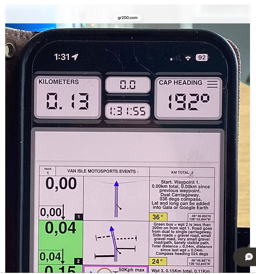
You get the Rally Computer information plus the roadbook PDF. Scroll it up and down in the usual smartphone manner and tap the screen to lock the display.
Lastly, if you tap the three bars in the top right hand side of the display you get a “utilities” screen

Here you can switch between miles and kilometres, temporarily adjust the odometer calibration and turn off various Rally Computer features.
2.4.8. Other tech devices that can be helpful.
Remote GPS receiver

I have already mentioned the remote GPS receiver, the SkyPro XGPS 160. The GPS receiver chip in your smartphone has its maximum sensitivity vertically up from the plane of the screen. It’s minimum sensitivity is parallel to the screen. Usually on bikes, the phone is mounted on a handlebar mount that holds the phone in an orientation giving best vision to the rider, and almost the worst sensitivity to GPS signals. It is remarkable that the GPS function works as well as it does…
RRR takes data from the GPS chip to run it’s geolocation functions. You might want to consider using a remote GPS receiver….
NOTE: given the RRR takes data continually from the GPS chip inside the phone, that mounting the phone near vertically puts the GPS chip in a most disadvantageous orientation and the GPS chip data drives the RRR odometer, it is reasonable to expect any interruption in reception of GPS signals will lead to under-reading of distance measurements (and consequential speed measurement inaccuracies). This is one of the reasonably foreseeable sources of distance measurement inaccuracies and one that a remote GPS receiver can be expected to eliminate.
A further consequence of the function of the GPS chip is that it is in constant activation. This puts a significant drain on the battery of the phone. If you are using an old phone, the performance of the battery is likely to be more than somewhat diminished….
USB charger
You are going to need a wired-in USB charger to keep the battery in your RRR phone topped-up. It isn’t a difficult job to wire a USB charger in to the electrical system of your bike - just make sure you run it off a switched live so you don't need to worry about flattening your battery overnight.
Bluetooth remote controller

This is where practicality meets a little bit of luxury. You can control your RRR app with a handlebar mounted Bluetooth controller and scroll the roadbook up and down without taking your hand off the handlebars. These controllers come in a wide variety of shapes, sizes and costs but they all perform the same function. You could be forgiven for believing they all had the same insides to them…. I couldn’t possibly comment! Add a second (or third?) USB charger to keep it fully powered up.
And finally, a handlebar phone mount or some other place to keep you RRR phone safe and visible at all times - you are going to be a great deal of looking at it!
How the apps work in the context of the events.
How the apps are applied to the events.
How the VIME format differs from other formats - and how it is similar…
Richta, what it is, how it works, why it works.
Smartphones, their strengths and weaknesses.
How to up-spec smartphones without spending $$$/£££.
Ways you might think you can “game the system” and reasons why you (probably) can’t.
Richta (timing) Control Point = RCP
2.5 “Gaming the system. (also cheating or bending the rules) can be defined as using the rules and procedures meant to protect a system to, instead, manipulate the system for a desired outcome. .....structures in companies and organisations [tend to] drive behaviours that are detrimental to long-term organisational success..... For some, error is the essence of gaming the system, in which a gap in rules allows for errant practices that lead to unintended results...... although the term generally carries negative connotations, gaming the system can be used for benign purposes in the undermining and dismantling of corrupt or oppressive organisations."
It is possible to carefully read the rules and sometimes find ambiguities with which to derive an unintended and potentially unfair advantage - read up on how Colin Chapman of Lotus Cars was able to outsmart the Formula One blue blazer brigade of the time....
Being a past "bender-of-the-rules", I am mindful of the possible ways it is possible to bend the competition rules for TSD motorcycle rally and thinking how can events be set out to prevent gamesmanship.
Scenario One. Calculating the target elapsed time for each leg and over the complete stage.
Scenario Two. Lurking short of a Richta Control Point (RCP) to run the clock down.
Scenario Three. Making up lost time.
Scenario Four. Leveraging neutralised legs for lending "essential assistance"
Scenario Five. Plotting the roadbook into Gaia.
Scenario Six. Following-on.
Scenario Seven. Cutting the course.
Scenario One. Keeping to a time schedule.
On the face of it, it should be a relatively easy arithmetical challenge before you start to read the required average speed for all legs from the roadbook, add up the total distance that average speed applies over and calculate the target elapsed time for each and every leg. Add up the target elapsed times for all the legs and you should have the target time for the day's route.... Shouldn't you?
Well, yes and no.
Difficulties arise when you arrive early or late at the next RCP. Each leg will be timed from the previous Control Point. If you have arrived early (or late) at that RCP you will need to subtract or add the time difference to your prepared schedule.
And again for each subsequent leg...
There are some people who have the mental arithmetic abilities to do these sums in their heads, while navigating a course, and riding a motorcycle, but how would they know if they are early or late at a RCP?
Well, if you have an audio system in your helmet connected to your phone you will hear Richta giving you a verbal report on your passage through the last RCP... again there's a but! You don't know where the RCPs actually are. Your friend-in-your-ear has just told you how you did, it didn't tell you how you were doing as you were doing it.
Also, given each leg is timed from the previous RCP (and not from the start CP) each leg is a stand-alone entity. Any time penalties incurred cannot be redeemed. They are set in stone. Move on! You start afresh on the next leg...
Average speedometers are one of the "not allowed" pieces of equipment. I can't sit on everyone's shoulder and confirm that an average speedo hasn't been used but remember, an average speedo needs to be zeroed every time the set average speed changes. You need to stop and zero the "average speedo", the ones I have seen are fiddly electronic ones with small buttons that you need to take your gloves off to adjust (loosing time....) or large mechanical devices that will be spotted at scrutineering, start and finish lines.
There is a further hurdle to "schedule doping" that rolls into the next point.
Scenario Two. Lurking.
One of the jolly wheezes rallyistas of yore would get up to if they knew they were ahead of time was to hurry through a section and, because rallies were often run at night, the timing Control Points would be brightly lit and visible from, well, half a mile off. Knowing they were ahead of time the last half mile would be driven at a pace commensurate with an arrival on time. To counter this caper, event organisers would find themselves setting faster and faster required speeds which eventually in some circumstances led to absurdly high speeds leading to the end of this kind of motorsport in some countries, for example the UK.
As things stand in BC, TimeSpeedDistance regularity rallying (bikes and cars) is permitted in the relevant road traffic legislation. It is presumed to be in our interests to keep it that way. We can contribute to that by keeping leg speeds sane. In order to prevent Time Control lurking and the power spiral leading to ever higher speeds (on public roads) the simple solution is to simply hide the Time Control locations.
Richta time Control Points (RCPs) are GPS coordinates. You would never know you are at a RCP - unless you hear your phone telling you how well you did over the last leg. The canny event organiser also takes care not to have the RCPs in the same place as roadbook waypoints.... the RCPs will be somewhere in the vicinity of waypoints but there will be many more waypoints than RCPs. The RCPs may be anywhere from 200metres before a speed change to 200m after. There may even be an extra RCP in the middle of a single-speed leg. You won't know until after you have passed it! Difficult to game that...
The Richta legs and RCPs will be set so that it is impossible to score a zero time penalty in any leg - except by accident. If a leg takes 17 minutes to ride, at 30kph it is 8.5km long (5 miles, kind of short for a day that may be 125 miles long)... 17 minutes is 1020 seconds. Each leg is timed to the closest second, over rough terrain. The chances of achieving a 1 in 1000 accuracy, well, I will know these courses and I wouldn't expect to score any "perfect zeros"!
Scenario Three. Making up lost time.
I've already touched on this in Scenario 1. There are a number of recognised ways of timing a rally. In Richta there are two names given to timing schemes, Evansville where each leg is timed from the previous start and Maddison where each leg is timed from the previous RCP.
If you gain or lose time in an "Evansville" timed event you can attempt to make that time up or lose it by adjusting your speed over the next and subsequent legs. Given the leg speeds will be set at the upper end of what the course designer considers prudent, the implication is a late rider could be tempted into riding at imprudent speeds over what are essentially wilderness roads. Puts us back in the position of spiralling speeds and legislative outlawing.
In a "Maddison" event, each leg is timed from the previous RCP. Each leg stands on its own (so to speak). There is no need or point in adjusting your speed over subsequent legs, you need to be concentrating on the next leg!
Scenario Four. Leveraging neutralised legs having given "essential assistance".
There is a fatalistic mindset of those people aiming to climb to the summit of Everest. It's a death zone and to stop and give assistance to someone in difficulties will probably result in you also getting into difficulty yourself and will certainly put the kibosh on your summit attempt - so people are left to die and stepped over when they do.
We are not in that situation! The requirement will be if you come across someone in difficulty you will stop and lend whatever assistance you can. In the case of a serious injury, that may mean two or three event riders working together to stabilise the casualty, activate their satellite SOS devices and get word out to the outside world. While we may be in what is a "wilderness area", we won't be more than 50km from cell phone signal. 911 works and late-model smartphones have satellite calling capability.
Any event rider who pauses to lend assistance and subsequently scores a time penalty max on that leg will have their max neutralised to a zero perfect score for that leg.
Now, imagine two rally riders seeking to metaphorically stuff fish bellies with lead weights. Big-end Bob and Little-end Lol. Bob hatches a plan that he will "lend an essential hand" to Lol on leg 2 and Lol will repay the favour two legs later. Each will claim a zero for their legs... catch is (apart from the blatancy of their deceit) is that each would have to take a max time penalty on the leg that they had their "spot of bother" on. Also there may well be more than ten, timed legs in a day's ride, minimising the effect of a single zero-leg score. Busted!
Scenario Five. Plotting the roadbook into Gaia.
This isn't strictly a Richta wheeze but a more general roadbook wheeze.
I ask people what class they are entering when they send me their entry fee so that I can be careful not to sent the Gaia track to the roadbook entrants, there is nothing to stop ambitious roadbook rallyists from reverse engineering their roadbooks into Gaia or some other mapping app. Such study takes time, especially if you make a mistake in your transposition.
I will email out the routes, in the appropriate format about a week before the event. The Gaia people are in for a touring ride so there aren't any secrets to be kept. The roadbook people have the greater puzzle.
Ours is an entry-level, grassroots event - no prize money, no titles or glory. Higher level events make the roadbooks available sometimes only with a few hours or no hours notice, by pdf or paper scroll. At this stage of the game, I am not going to be printing up dozens of scrolls. The roadbooks will be emailed out as a pdf for entrants to print or load as they wish. Study them in the two or three evenings you will have to study them - then you have to ride the course!
If, in the future this proves to be a significant challenge to fair competition, I will switch to distributing roadbook PDFs with only an hour or two's notice.
Scenario Six. Following-on.
Again, this isn't a Richta wheeze but a general rally wheeze, also this isn't anything to do with Following-on in cricket, or perhaps it is. In cricket, a team who bats second and scores significantly fewer runs than the team who bats first may be forced to take their second innings immediately after their first.
In particularly dry and dusty conditions, it is possible for the dust trail kicked up by leading riders to be followed by subsequent riders. It was one of the observations from the GR200 - including when one of the leading riders took a wrong turn and was followed by four other riders who were following the dust cloud.... This scenario is also a potential problem in high-level rally riding where the overnight leader is required to be the first to start the following morning. In the right conditions, dusty or soft surfaces where tyre tracks can be seen all sorts of clues can be gathered.
A one minute start interval is not sufficient to prevent following-on. Sometimes two minutes isn't enough either. Depending on the size of the field, the start interval will be adjusted for the best running of the day. The rider who finished last in the standings on the previous day will be given the option of starting first and not being the last person in, or starting last and having the advantage of following other tyre tracks. Everyone else will draw lots at the start time to decide the start order.
Scenario Seven. Cutting the Course.
You wouldn't dream of it, would you.....? But others might!!!
There may be places where the course could be cut, shortening the distance of the ride. It may be an out-and-back section, it may be two roads that run more or less parallel and the route is up one and down the other.
You can bet your sweet bottom-bracket I will be putting RCPs along those sections at at the turn-round point. Miss the RCPs and you will score maxes for the leg before and the leg after the missed RCP.
Suspicious patterns of missed Richta RCPs WILL show up in the score reports and will be investigated.
How to minimise your time penalties.
Ride the roadbook not the Richta Control Points. You won't know where the Richta Control Points are and some will definitely be in places you don't expect. They will not be like police speed traps that with a practiced and alert eye you can spot a mile off.
Calibrate your speedo. Read up on how to calibrate the Rally Navigator - Roadbook Reader speedo. Use Gaia to set a course near to your home of a known distance and calibrate your speedo and odometer.
Use your odometer to measure distance between roadbook waypoints, not the overall distance travelled. There will be distance measuring errors along the way - no escaping that. If you ride to your tripmeter, zeroed at every waypoint of significance, you won't compound your distance errors.
Practice riding at a constant AVERAGE speed over different terrain. It's unavoidable that you will be asked to ride at say 40kph up one side of a mountain and down the other side also at 40kph and there may be a RCP at the top to give a measure on the way up and the way down. That's the nature of the sport. Use your speedo to keep a constant speed when the going is constant and your innate speed-sense when the going is variable…
2.6. Some of the obscure points of cartography, topography and geometry. Maximising the GPS performance of smartphones.
Distance Measurement Discrepancies Explained. Remote GPS antenna/receiver for smartphones running mapping and timing apps
Typical spatial sensitivity plot of a smartphone GPS receiver chip.
This technical essay discusses and seeks to address the two known issues that limit the accuracy and precision of GPS devices when used in motorcycle backcountry navigation and rally timing. These issues are the discrepancies observed measuring distance travelled and the occasional non-detection of virtual timing gates by GPS location.
These two issues are related but not direct dependent on each other.
Methodological and equipment solutions are discussed.
2.6.1 Introduction
If you have followed the VIME blog or participated in a VIME event you will be familiar with the conversations around the apparent (real in many instances) mismatch between distance measurements between two geographic points and the GIS (Geographic Information System) predicted distance as produced by Rally Navigator (the computer program used to write roadbooks) when measured by GPS odometers. Also there are instances when smartphones fail to detect their presence at GPS locations that correspond to rally timing points.
2.6.2 Sources of discrepancies.
Car regularity (TSD) rallies are famous for the precision that road distances are measured to. To be fair, the precision achieved is a combination of highly calibrated odometer instruments and methodological techniques that do not easily transfer to motorcycles.
To expand on this, car TSD rallies are set using a precise, wheel-driven odometer that regardless of it’s variation to the actual, on-the-road distance, is used as the “master measurement”. Distances between tulips are measured with this “master odometer” and are written into the roadbook as the “event gold standard”. To enable competitors to calibrate their odometers (usually wheel driven) to the event master measurement, a calibration leg is set at the start of each route that allows each car navigator to observe the difference between their odometer measurement and the master measurement. This is then quickly converted into an “adjustment factor” that each leg distance needs to be multiplied by, in-car and on-the-fly to convert their measurements to the master measurements.
The amount of work required by event course setters is quite considerable as master measurements need to be written into the roadbook during the editing and proof reading process (an adjustment that requires some “track manipulation” in Rally Navigator), the exact path on the road needs to be apparent to crews and of course copious notes need to be made by the course-setting crew.
2.6.3 The first two sources of error for motorcyclists….
The rally motorcyclist is constrained in their choice of odometer to either the wheel driven odometer that may be a secondary add-on device or part of the machine’s speedometer (which can be notoriously wayward once the statutory inaccuracy is accounted for - 10%+4kph above the true speed but no lower than the true speed.
Add in changes to the tyre size used, deep knobbly tyres wearing, tyre pressure changes and “tangential route” errors it is not surprising the speedo odometer can only be partially relied on.
OR
The amateur motorcycle Rallyista is mostly confined to using a GPS driven odometer - either as a function of the roadbook PDF reader of choice or a standalone device.
The workload of the rider would probably exceed manageable limits if a “calibration leg” were to be provided for riders to calculate their odometer calibration factor and have to multiply every distance in the roadbook by this number AND keep a running tally of the overall distance travelled in addition to adjusting the control point to control point distances.
Rally Roadbook Reader GPS odometer “offset adjustment”. This smartphone app has an odometer calibration offset adjustment in the settings, up to +/- 5%. On reflection, the intended purpose of this feature is to permit “synchronisation” of the GPS odometer to the “master odometer” used to set car TSD road rally courses. If you remember, tarmac rallies have the distances between waypoint tulips measured “over the ground” rather than relying on trigonometric GIS calculated, horizontal displacement distances.
The next source of error comes about from the GIS distance measurements made by Rally Navigator. The GIS system calculates the distance between the map points entered along the proposed route. The computer system is not able to automatically plot a smooth course on the ill-defined gravel roads, so you get very precise trigonometry-derived measurements of somewhat poorly positioned geographic locations. This inaccuracy can be mitigated by placing strategic control points at unambiguous locations such as bridges over rivers, major road junctions and immovable geologic features. These points can then be used to reset the route odometer to the roadbook and go again.
2.6.4 Tangential and Orographic errors.
In addition to curved routes plotted in Rally Navigator being rendered as a series of straight lines (and so introducing a distance error), the path ridden by a motorcyclist is likely to differ from the path plotted (on the GIS map) in Rally Navigator and the median route of the road.
The mapped world, it would appear is made up of a series of straight lines while the ridden world is made of beautiful curves…
Orographic? “Orography is the study of the topography of mountains, and can more broadly include hills, and any part of a region's elevated terrain.”
Simplistically, maps are a two dimensional representation of a three dimensional landscape. The ultimate bird’s eye view. There is an unavoidable distortion of distance when representing steep ground on a map.
To explain, taking a bird’s eye view of a road on flat terrain, from the high mapmaker’s viewpoint, the over-the-ground distance along that road is as the mapmaker sees it.
Now compare that situation to an extreme Loonie Tunes world where the roadway then goes straight up a vertical cliff face (of say 1000metres length). In this make believe situation, the roadway then goes would be 1km long, straight up. But from the mapmaker’s extreme altitude viewpoint directly over this cliff, the road would have no distance at all. Just a line on the map.
While this cartoon example is absurd, reality lies between the horizontal and vertical and demonstrates how the projected map distance of a road going up a hill will always be less than the over-the-road distance.
2.6.5 Smartphone GPS receiver chip limitations.
This image indicates the spatial sensitivity of the GPS chips typically found in smartphones. Most sensitive straight up from the screen.

To back up a little, all things GPS rely on the antenna-receiver picking up the radio signals emitted by the GPS satellites in orbit around the planet (no, it’s not a flat Earth!). They are not strong signals and anything that obscures the view of the sky will interfere with the GPS signal. Tall buildings, mountains, trees, leaves, the orientation of the receiver chip to the sky…
Typically, smartphone GPS receivers are accurate to a 10m (30foot) diameter circle under open sky…. Introduce obstructions and this “circle of uncertainty” will increase.
Smartphones also often receive GPS signals on one radio frequency and update at a rate of once per second (1Hz) and draw positioning data from the US NAVSTAR GPS satellite constellation.
Take another look at the colour image at the start of this essay, the colour coding helps to demonstrate how the receiver sensitivity varies with orientation.
The receiver is most sensitive in the “up” direction when the phone is held flat as if it were on a tabletop.
The receiver is most insensitive when it is held vertically as in a pocket.
Now think how most people carry their phones…. Either near vertically on a navigation tower or vertically in an inside pocket.
Combining all these challenges to smartphone GPS performance, it is surprising to me that the GPS works as well as it does.

Nav tower orientation for smartphones - not the best for GPS sensitivity
So here is a worked out problem….. if the GPS “circle of uncertainty” (to borrow from Mr. Heisenberg) is 10metres across and the GPS sampling rate is 1 Hertz, how far would a motorcycle travelling at 60Kph travel in one second?
60Kph = ( 60/(60x60) ) x 1000 meters per second. Using BODMAS this simplifies to
1/60 x 1000 m/s =16.667 m/s…
At 60Kph, a bike would cover 16 2/3 metres in a second - and the circle of uncertainty could be 10 metres. On the face of it, the bike and rider could come and go before the GPS had a chance to register the fact.
Fortunately the builders of the GPS timing system used (Richta) realised this and set the detection radius of control points to be rather larger than the “circle of uncertainty”.
Nevertheless, if the view of the sky is hampered by trees and foliage, and the phone has been out of contact with the GPS satellites for a long enough time to require satellite signal reacquisition, that GPS control point may go unrecorded through no fault of the rider or the course setter…
Glossary:
GPS = Global Positioning System
GNSS = Global Navigation Satellite System
GLONASS = The Russian GPS satellite constellation. 24 satellites
Galileo = The European satellite constellation. 30 satellites
BeiDou = The Chinese satellite constellation. ?35 satellites
NAVSTAR = The US satellite constellation. 32 satellites
So we have these following points to bear in mind…
Assume the GIS (Geographic Information System) trigonometrically calculated distances between points to be always correct - but only when measured by GPS odometers.
Also assume the GPS measurement of distance travelled (and implicitly, speed) is also always correct, but only when used against GIS generated distance measurements.
The course plotted in the roadbook writing computer system won’t always exactly match the exact route of the road, and
The route followed by a motorcyclist won’t always exactly match either the median route of the road or the route plotted in the roadbook.
There isn’t an easy way to verify and edit into roadbooks “master odometer” distance measurements made when verifying and pre-riding routes.
The odometers on motorcycles, regardless of type are always liable to differ from the roadbook distance measurements, although it is difficult to say what measurement is righter or wronged than others…
Take steps to minimise the challenges your smartphone has in finding GPS satellites from which to take data
This has been a rather long journey to arrive at the sources of GPS variances, disagreements, deviations - call them what you will. But what is to be done about them?
Taking them in order…
In the absence of a “super odometer” for the motorcycle rally setter to use (remember that lucky person has the same equipment as event competitors), the trigonometry calculated distances between waypoints has to be taken as gospel - EVEN THOUGH IT ISN’T!
Geographic Information System (GIS) computer systems calculate the horizontal distance between two marked points, not the on-road distance. GPS odometers also calculate horizontal distance, wheel-driven odometers measure on-road distance.
There is no easy/cheap/swift way of doing distance measurements differently or better. Rally setters need to let it be known how they measure distance - GPS or wheel, horizontal displacement or on-road. Rally-setters and participants can develop an empirical technique of noting roadbook distances at strategic, incontrovertible geographic locations and resetting their trip odometer to the roadbook distances without troubling themselves with questions about whose measurement is correct.
VIME events will be measured using the GPS/horizontal displacement method.
Within the instrumentation and processing limitations of smartphones, their distance-measuring accuracy has to be taken as incontrovertible. SMARTPHONE ODOMETERS MEASURE HORIZONTAL DISPLACEMENT, NOT ON-ROAD DISTANCE.
There are steps that can bet taken to improve the sampling rate and location precision of smartphone GPS systems, more on this later (GPS remote antenna/receivers and specifically the SkyPro XGPS160).
The course plotted will always be a series of short straight lines and the road on the ground may differ in location and route to that shown on the map.
Ride a bike over a rough road and you will choose the lines of least resistance. The distance discrepancies you introduce will be added to the overall discrepancy. Some will cancel out, others will add.
While it’s not strictly true to say that control-point to control point distances as measured in Rally Navigator can’t be adjusted (extra path diversions or corner shortcuts can be introduced in order to massage leg lengths up or down), this editing would require every leg length to be measured, the measurement would be subject to every source of variation discussed here and every “intense” competitor would need to calibrate their odometer and multiply every roadbook distance by their “adjustment factor” - as mental arithmetic. This would create more angst among riders than acknowledging the measurement shortcomings and using empirical workarounds.
This is a methodological difficulty covered in point 2 above. Horizontal displacement versus on-road distance, GPS versus wheel driven. Two different measurement systems not to be combined if reliable results are desired!
This is the “if you didn’t understand all the foregoing, just do this” bit…
If you’re on an android, set it to airplane mode so it can concentrate on your needs.
Carry your Richta-running phone and your roadbook PDF-reading phone as close to horizontal as possible.
Reset your odometer (whether it is wheel or GPS driven) to each “waypoint of significance” distance at every opportunity.
Consider using a remote GPS receiver-antenna. This is the point of this essay.
Dual Electronics Corp. SkyPro XGPS 160

After much consideration, comparing the different features and capabilities of different receiver-antennas and reading about which model other rally enthusiasts had chosen, I bit the bullet and bought one of these.
$230 plus all the usual hidden costs, I bought mine from Amazon rather than traipsing around the gadget shops.
The plus points:
It receives GPS data from both the US GPS satellite constellation and the Russian GLONASS system simultaneously.
It can feed that information to up to five devices simultaneously by Bluetooth.
It can operate while being charged from a USB charger.
iPhones can take Bluetooth data from more than one device at a time - so you can use a Bluetooth pdf controller to scroll your roadbook at the same time that the XGPS160 is feeding it with GPS data.
It pairs with iPhones really easily
It can also talk to Android phones although the pairing process is more complicated.
It updates GPS data a a rate of up to 10 position samples per second (ten times faster than phones typically).
The minus points:
It is fairly bulky, 70mm x 55mm x 22mm and the sticky holder is 110mm x 120mm x 25mm
It has to be mounted horizontally, facing straight up.
It isn’t rainproof - it is intended to be mounted on the dashboard of a car or light aircraft under the windscreen.
Some ingenuity is required to successfully mount it to a rally motorcycle used in the harsh conditions that can be expected.
What it won’t do:
It won’t get your GPS to work in impossible situations, like in skyscraper urban environments, in tunnels.
It won’t solve any of the distance measuring problems caused by the issues described above.
What it should do:
Higher frequency data sampling and drawing data from two satellite systems simultaneously should minimise missed GPS control points and “uncounted kilometres travelled” due to the GPS reception dropping out.
Does it do it?
I shall test it and let you know. I suspect I am not doing anything new or unique here, these little devices have been used in the car communities for quite a number of years now but to my knowledge not transferred to a motorcycle environment.
This is how I have fitted the XGPS 160 to my bike…

The XGPS 160 does what its makers say, it can talk to up to five devices by Bluetooth while being powered from an external USB. iPhones can receive Bluetooth from (at least) two devices simultaneously.
The closing message is this.
There isn’t a perfect solution for our distance measuring difficulties.
They arise from the combination of methods, systems and devices we use in the steep environments characteristic of VIME events.
These combinations cause distance measuring challenges that can’t easily or cheaply be overcome.
So
We continue to live, ride and play in a crazy, mixed-up rock and roll world using methods and instruments with known flaws to achieve the improbable. Beyond all of the above, there is a limit to the accuracy and precision our efforts can achieve. In the light of all these flawed and sometimes mismatched measurement systems we have ways of getting the best out of them and it’s probably best not to take ourselves too seriously ;)
With the agglomeration of all the marginal discrepancies outlined here AND the suggested mitigation strategy of resetting the odometer at every waypoint of significance, there is little point in adopting the car regularity rally custom of having an odometer calibration leg at the start of each route as the discrepancy between different odometers will be manifest as soon as the first route “challenge” is encountered (lost satellite signal, road incline, route tangent, difference between GIS and actual road placement). An odometer calibration leg would not add anything to distance measurement accuracy.
There is yet another source of GPS odometer discrepancy not yet discussed… Horizontal data sampling estimations.
A GPS odometer measures distance travelled using the location data breadcrumb trail it builds up from the GPS locations it collects.
If the antenna-receiver should loose connection with the satellite constellation it is using, the device won’t have any information about the route it was taken on while it was off-line. It has already been noted that foliage cover obscuring the view of the sky will be sufficient to blind the GPS.
When satellite communications are re-established, the odometer will metaphorically draw a straight line between the two known positions and assume that was the route taken.
If the actual route was anything but a straight line, there would be a clear difference between the mapped (twisty) distance and the assumed straight GPS distance.
If a remote GPS receiver/antenna decreases the likelihood of satellite communication being lost, this source of discrepancy will be eliminated or reduced. In signal processing, this is called an aliasing artefact. See https://en.wikipedia.org/wiki/Aliasing
Showing the effect of under-sampling an input signal when reconstructing to give a result that bears little resemblance to the original (aliasing error).
2.7. Applying it all to a real event.
If you have already participated in a VIME event this update will probably not tell you anything new (perhaps it will), but if you are contemplating your first event this will tell you how the event works and how to turn in your best possible result - at least for your first go....
You may have noticed that for other sports, finding information on how to go from an absolute not-doer to an able-to-doer isn't always easy to find? Here I hope to dispel some of the mystery...
One of my backgrounds is triathlön. I never reached a pinnacle of athletic performance but I was OK. I could complete an event without incurring any penalties or making any stupid mistakes.
I learned from experience not to keep my wristwatch and Velcro band timing chip over my wetsuit (you can't get your wetsuit off - think about it), to put my cycling helmet on first in T1 and take it off last in T2, to take an extra twenty seconds to remove any grit or gravel from my feet before putting cycling shoes on, to make sure the bike was in an easy gear for the start of the bike.... The list goes on and on.
Every sport with rules has an "insider's knowledge" of how to get the best of the rules. The need to know those things present one of the barriers to participation. In the spirit of "Sport For All" - if you go back that far - I would like to write a beginner's guide to how to do Backcountry Navigation Trial.
2.7.1 First, the basics...
You need
A full-entitlement motorcycle licence (Class 6)
A road-legal, registered and plated Trail, Dualsport or Adventure bike
A road insurance policy from ICBC or your home jurisdiction insurance provider
As the minimum age for a Class 6 licence appears to be 19 and the Age of Majority in BC is also 19, any issues of Child Safeguarding, Protection or loco parentis on the part of VIME as event organiser are avoided by having a minimum entry age of 19.
The backcountry roads used for VIME events are all classified as highways within the meaning of the BC traffic laws and occasionally require travel along tarmac roads - hence Off Highway Vehicles cannot be included. Competition bikes are also excluded.
Requiring all bikes and riders to be "road insured", coupled with the fact that the routes are all technically highways means that each rider brings their own insurance to the event (ICBC does not exclude navigation tests as an insured driver activity, provided the route stays on "gazetted highways" - I've checked). This makes for straightforward event organisation.
The route difficulty will never be as hard as "hard enduro", as testing as a motocross race or as technical as motorcycle trials. You will need to have a basic level of off-road competence though. Smaller bikes are easier to manage than the largest Adventure behemoths, the smallest-capacity Honda CT125 in low gear will get through even if the suspension limits performance compared to say a DRZ400.
2.7.2. Now the equipment.....
Moving on to the kit requirements
Usual motorcycle riding equipment - remember these are "highways" as well as backcountry trails... Helmet, gloves, boots, jacket and trousers, body armour if that is your thing, food and drink supplies, spares and tools as you think fit.
Personal First Aid and survival supplies. As a minimum a space blanket or survival bag, Lysol wipes, sticking plasters, bandages.
Satellite SOS calling device - InReach or Zoleo are the two that immediately come to my mind but there are others and there will be many more to come. Strongly recommend as there is little cellular service in the north of the island and none in the mountains. Update: the newest iPhones have a satellite communication capability.
Tyres will need to be suitable for mud and snow as a minimum. Trials knobbly tyres are good, MX or Enduro tyres are probably overkill, road-oriented "adventure" tyres are probably not the best choice as these routes can be expected to be 100% off road. I have found a MT21/D606 combination works very well for me, YMMV...
2.7.3 And the tech equipment:
Two smartphones, both of which can be old and neither of which need a SIM card. One has Rally Roadbook Reader app loaded, the other has Richta Competitor. Via WiFi, load the event details onto the phones before you leave home. You won't be scrambling to find a wifi hotspot on event morning...
If you have entered the Gaia Tourismo class, you will need just one phone with a subscription-paid Gaia with relevant area maps downloaded along with the event route.
Both phones need a usb charging lead wired in as the battery life won't be long enough to last the whole day. If your bike doesn't have charging ports, you will need to wire those into your bike.
You will need a mount of some sort to securely hold the Gaia or Roadbook Reader phone so that you can see it at all times while riding. That may be as simple as a handlebar ball mount or it could be as sophisticated as a rally navigation tower. Your choice!
There will be three class options,
Gaia Tourismo - intended as the entry-level class.
Roadbook - without GPS timing.
Roadbook plus Richta gps rally timing.
Event awards can only be given to participants who ride the Roadbook-with-GPS timing category
2.7.4 Event entry, arrival and registration, sign-on and scrutineering.
You will enter the event on the "Shop" page of this website. You will need to enter your personal details (name/address/email/phone number) and you will be registered on the VIME website. You will pay for your entry by credit card through the Wix-owned website (which means I do not keep any of your credit card information, one less legal responsibility for me to manage).
You will be asked if you are entering the Tourismo or the Roadbook category - you can change your mind up until the routes get sent out (about a week before the event).
Upon your arrival at the event venue there will be a Registration desk where you will need to present yourself for some formalities:
You will need to register your presence at the event (for head-counting purposes).
You will need to show your driving licence and insurance paperwork - no details will be recorded other than you presented your credentials and that they were in order (again, a level of data management avoided).
You will need to give the name and contact details of someone who can be contacted should anything untoward happen - of course, they need to know about this.
You will need to Sign-On. This is the record that you are present, are giving informed consent to your participation, that you are fit and equipped to participate in the event, that you take responsibility for your own actions and that you acknowledge the organisers and staff of the event have taken all possible precautions to put on a route and an event that is free of artificial hazards.
You need to present your bike for scrutineering. Nothing super-technical about this, just "is it all there?", "does it all work?", "is it fit for purpose?"...
Then if all is well, you will be given your Welcome Pack that will include your event stickers for your bike and your participant number. Stick them on your bike somewhere where they can easily be seen from the front.
There will be a rider's briefing meeting where the essentials will be discussed and any last minute changes will be announced.
2.7.5 Gaia Tourismo
Gaia is a (Geographic Information System GIS) GPS mapping app. There are many such mapping apps and while they all use much the same data and perform the same function, they each have differences in how they are operated. To minimise the variation and hence the likelihood of things going wrong, Gaia is the mapping app of the events!
You will need to buy an annual subscription for about $60, download the app onto your smartphone and then download maps of the north of Vancouver Island into the memory of your smartphone. Having done that, the phone is able you use your GPS position from its GPS chip and pinpoint your location/speed/heading/altitude/elapsed time/distance covered on your downloaded map - even in the absence of any cell signal. Magic!!
About one week before the event, Tourismo riders will be emailed a Gaia hyperlink that will show the event route in Gaia. It will be the same route as the Roadbook route. You are on your honour not to divulge the route to anyone - especially anyone riding the roadbook category.
So far, I have not had any problems with routes being divulged. Should that occur, the publication lead time can be shortened to as little as one hour before the event or less...
Tourismo riders can ride singly or in groups to their own preference, following the line on the map. You will see there is not any competitive element in the Tourismo classification, just a good long day out in the hills on the bikes. This is as much "sport" as some people want and provides an easy on-ramp to this Motorsport genre.
While the Tourismo riders will be permitted to start at their convenience, they will be required to start at a separate time to the roadbook riders to enable a clear separation between the two categories.
2.7.6 Roadbook and Roadbook + GPS timing classes.
These classes are intended to provide an introduction to motorcycle Rallysport and a competitive event for those that wish - without breaking the law, specifically with regard to racing and speed trials.
The routes are described as roadbooks, written using commercial Rally Navigator software (yes I've paid the commercial licence fee...).
The routes are divided up into "legs", each with a target average speed which is less than the posted speed limit.
Riders competing for honours will start singly at intervals between one and three minutes depending on the size of the field. New participants will be permitted to ride in pairs for their first event.
The route roadbook will be distributed no more than one week before the event, by email as a pdf. Participants are at liberty to either print the pdf up as a scroll or save the pdf to their smartphone and display the roadbook in Rally Roadbook Reader.
There are a number of advantages to using Rally Roadbook Reader (RRR), it comes with a internet clock, it has a compass, a speedometer and a GPS-driven odometer which will most closely correspond to the distance measurements in the roadbook (also GPS distances). It is straightforward to correct the RRR odometer reading as you go along, aligning the odometer with roadbook junction distances.
Your challenge will be to ride each leg in such a manner as to complete it at as close to the set average speed as possible. It will not be straightforward as within each leg there will be elements where the average speed seems impossibly fast followed by elements where the called for speed seems unreasonably slow. The expectation is that you pick up speed in the easy bits to compensate for lost progress in the difficult bits. You thought this was going to be easy?
Your progress will be recorded by the timekeeping app on your other phone. The timekeeping app is Richta Competitor. It runs best on iOS, iPhones to you! You have to download the route GPS gates and elapsed time data before you leave home - AND REMEMBER TO START THE APP BEFORE YOU START THE EVENT......
The app will record the time you started each leg, it knows what the set elapsed time to the next gate is and records the time you got there. The app then works out how many seconds early or late you are and records that number of seconds as your leg time penalties. Once you have completed the course it records how many of the GPS timing gates you triggered and totals your time penalties. When you get to the finish and reconnect your Richta phone to the internet (by cell data, hotspot or wifi), your scores for the day are uploaded onto Richta RallyMaster (me) and Richta Scoreboard (for all the world to see).
This form of Motorsport does not respond well to the application of brute force and applied ignorance. Sixty mph in the wrong direction will be entirely counterproductive. "Red mist" competition will get you nowhere fast. This is competition for the "thinking rider". Steady, accurate riding and navigation will beat ballsy, eyeballs-out riding everyday and the events are arranged to ensure precisely that happens.
2.7.7 At the start and during the event. What we the event crew do. What you the participants do
At the start
The start order will be decided by lottery, Prologue results and the previous day’s results .
You will know what your start time is and you will be called to the start in order.
As you are carrying your own timekeeping app, there is no start flag to drop. When you are given the nod you can leave the start area. The first gps timing gate will be a number of kilometres up the road, so it is a very relaxed start.
The Start List will form the first "census" of riders on the course. There will be other "Passage Controls" around the course to keep track of riders. The final census will of course be at the finish line. We count you all out, then count you all in again. The last gps timing gate will be a number of kilometres before the finish line - so the finish will be equally relaxed as the start.
Event participants will navigate the course using the roadbook as the sole means of navigating. RRR has a compass and broad compass headings are given in the roadbook as part of the instructions.
You will have a general idea where each of the Richta timing gates are - but you will not know their exact location. This prevents gaming the timing system by arriving early, lurking short of the gate while the timing clock runs down then making a dash for the gate.
Each leg is timed independently of all others. Make a mess of a leg and you can't redeem lost time by arriving early at subsequent gates. THERE IS NO POINT IN RACING THE COURSE, THE CLOCK OR ANYONE ELSE!
Event staff will be riding the course, keeping an eye on what is going on and looking for riders in trouble. There will be a pickup truck or two around the course to recover any dead bikes.
Riders needing emergency services are to use 911 on a phone if there is cell signal and press the SOS button on your InReach or Zoleo if there is not. Recent model smartphones are satellite-capable.
If you come across a stranded rider, stop and help. If you consequently abandon your event ride, you can claim for your penalty points to be neutralised.
If you get lost, abandon your ride and start your Gaia to find your way to the finish, please remember to report in as safe so that we don't spend the evening and night pointlessly looking for you...
The winner of the event will be the rider who returns the lowest Time Penalty score. Seems pretty easy, huh? You are invited to come and give it a go! The events are held over the mountain roads of the north of Vancouver Island. It is all Crown land so no gates or private roads to contend with. The routes are confined to the roads - there is no cross country bushwhacking, we do not cross private property, we do not need to seek permission to ride these roads as they are already public roads. The roads will include the trickiest, most dramatic through routes I can find, taking you to some of the secret places on the island.
2.8 Untoward incidents and how to interact with forest industry traffic
Vancouver Island Motosports Events - Standard Operating Procedure for dealing with Forest Service Road traffic.
1/ This advice/instruction is written with the intention of establishing a standard method for VIME event motorcyclist to interact with traffic encounters on Forest Service Roads.
2/ The roads over which VIME events are run may appear to be deserted and deactivated. This is not so! These roads are local thoroughfares for residents, freight highways for the logging industry and recreational routes for the likes of us!
3/ Without exception, every other road user poses a potentially lethal risk to motorcyclists! THIS MEANS YOU! You are a vulnerable road user.
4/ The set average speeds for the regularity class of the event will always be equal to or less than the posted speed limits. The Gaia (navigation) class does not have a means of monitor in your speed. Regardless, you will be an foolhardy if you do not ride as if your worst nightmare is around the next corner…
5/ Keep to the speed limits. Keep to your side of the road. Allow sufficient space to your left to allow a loaded logging truck (lorry) to pass to your left with clearance. DO NOT CUT CORNERS!
6/ Look for dust clouds that may give you advance warning of the approach of heavy vehicles. Expect ATVs and SUVs to be driven recklessly and too fast to stop in the distance that they can see ahead!
7/ If you encounter an oncoming logging truck, slow and stop at the extreme right hand edge of the road and allow the truck to have the road. Look at the driver and follow their instructions, you may be required to move from your stopping position.
8/ If you come up behind a logging vehicle, do not try to pass it at speed! You will probably take the driver unawares, you won’t be able to see forwards and the road surface will be unsuitable for a high speed pass. Follow at a distance with your headlight on. Only pass if the driver slows to allow you past.
9/ If you lose significant time, report the situation to the event scoring team and your score will be adjusted.
10/ If you encounter lighter traffic, slow and give way.
Do not try to claim “Right of Way” from a hospital bed or mortuary.
11/ If you encounter someone else’s accident, stop and help. You can claim any lost time back from the event scorers.
There are no prizes of value at stake, nothing worth risking death for! Be safe!!
2.9 In Conclusion.
The events staged by Vancouver Island Motosports Events are specifically designed to provide accessible, affordable, competitive motorsports to road-legal motorcycle enthusiasts.
The format fuses elements of rallyraid (roadbook navigation), tarmac regularity rally (timed and scored legal average speeds between timing checkpoints), adventure voyaging (long distance backcountry routes and bike-packing camping), multi-day events (harking back to Six Day Reliability Trials) and common-or-garden road motorcycling(all event routes are over highway designated gravel roads).
In keeping with the “Everyman” approach, the VIME/GoldRiver format strips out procedural intricacies that characterise RallyRaid run to FIA/FIM principles and makes use of a few essential, intuitive roadbook icons. The format also makes use of a suite of free-to-use smartphone apps that enables affordable entry level but competitive motorcycle motorsport.
2.10 Appendices.
The GoldRiver Rules 2026. https://www.gr200.com/post/goldriver-rules-2026-draft-comments-invited
Vancouver Island Motosports Events, participant Liability Waiver. https://www.gr200.com/post/vancouver-island-motosports-events-participant-liability-release-and-waiver-2026-and-2027
JDB 2 May 2026
Comments