
TWO ROADBOOKS FOR YOU TO TRY. Port Alberni area, reasonably accessible from the Victoria and Vancouver area (via Nanaimo ferry terminals)
- Jonathan Binnington
- Mar 4
- 3 min read
Now that the clocks are about to change and day length is increasing rapidly, it is about time that we (you) all got out in the woods again…
These two roadbooks describe the event routes from a few years ago in the forests west of Port Alberni, to the north and south of the Alberni Inlet. The route to the north of the inlet is significantly more mountainous than the route to the south and you can expect the southern route to be clear of snow as much as a month before the the highest parts of the northern route.
These routes are supplied as PDFs in the same manner as VIME event routes always are. Previously I have written a blog post detailing how to load the PDFs into your iOS and Android smartphone/tablet: https://www.gr200.com/post/rally-roadbook-reader-the-app-the-tech-the-how-to-apple-and-android
Let me work through the first roadbook, page by page, line by line with screenshots…. Next are screen shots from the first three pages of the first roadbook

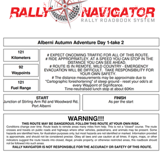


The first panel gives the route title, it’s distance (121Km), the number of waypoints (lines in the roadbook) and the fuel range needed.
The next box gives important information. READ IT! HEED IT!!
The next two boxes give the start and finish points, but where on god’s great green earth is Stirling Arm Rd and Woodward Rd???
Turn to panel two in the triptych…
The first line tells about waypoint 1. 0.00Km Straight on. Compass heading 167 degrees (true, grid or magnetic - it doesn’t make any difference just slightly east of due south).
Now the big give-away…. Are the bottom right hand box? 49deg 15.152’N, 124deg 52.701’W… that is the longitude and latitude of the start point. Enter those numbers into the search function of Gaia or your preferred GPS mapping app and it will show you exactly where!
So you have started. Ride forwards 0.07Km (70m) and you will come to the junction shown on line two. A Tee where you turn right. New compass heading 262 degrees with the new longitude and lattitude show in the bottom right hand box for that line. Ride in that direction.
After a further 0.28Km (280m), with a total distance covered of 0.35Km you will encounter a left kink in the road. The significance of this position (new long and lat shown bottom right) is that a GPS timing mark was recorded for the Richta GPS timing used on that event. The new compass heading is 222* and the set average speed was 50Kph.
Next Line, 0.81Km further, you can expect a minor gravel road on the left. New compass heading 274* with the new Long and Lat shown.
And so it goes on, line by line, junction by junction. It is important not to try to read too far ahead as it is easy to miss something relevant coming up next if you are trying to think about junctions three or four steps ahead… ask me how i know.
So now you know about the longitude and latitude data, you do not need the Gaia route to be given as a download as you can construct the Gaia for yourself.
Tarmac roads are shown as having a white centre, gravel roads are solid lines, minor gravel is a narrow solid line, paths are shown dashed or dotted depending on how small they are. The correct path is in blue with the arrowhead showing the direction, the not-correct direction is shown in black (if you have printed this in black and white, watch the arrowheads!).
Take note of the dialogue box on the right of each waypoint line - the way VIME roadbooks are written, the meaning of any significant feature is made as plain as possible in words.
Red exclamation marks indicate caution needed. The more exclamation marks, the more caution needed…. Obvious? Logical. Sequential!
This is how to follow a roadbook, the competitive element layers on the task of keeping to set average speeds between the GPS timing marks, and given the rough terrain, keeping to them isn’t quite so easy…
If you want to come over to the Island to try these two routes, I can recommend you consider staying at Char’s Place, an auberge type establishment in the centre of Port Alberni used by outdoors types with a lively concert calendar.
Char’s Landing: https://charslanding.com/

Now, the routes. Day 1.
And Day 2.
Come to the Island for a couple of days and give it a go! All the information you need is on https://www.gr200.com/blog
JDB 4/3/26

Comments